
Misuse of
Advanced Satellite Technology to Accelerate Man-made flash floods
Md Rahimullah
Miah 1, 6 ![]()
![]() , Md
Mehedi Hasan 2, Jorin Tasnim Parisha 3
, Md
Mehedi Hasan 2, Jorin Tasnim Parisha 3![]() , Md Bodrul Huda 4, Md Sher-E-Alam 5, Alexander Kiew Sayok 6
, Md Bodrul Huda 4, Md Sher-E-Alam 5, Alexander Kiew Sayok 6 ![]() , Md Shoaibur Rahman
7, Md. Amir Sharif 8,
Mohammad Belal Uddin 9, Shahriar Hussain Chowdhury
10, Md Amanullah Bhuiyan 11
, Md Shoaibur Rahman
7, Md. Amir Sharif 8,
Mohammad Belal Uddin 9, Shahriar Hussain Chowdhury
10, Md Amanullah Bhuiyan 11
1 Head,
Department of IT in Health, Northeast Medical College, and Hospital, Affiliated
to Sylhet Medical University, Sylhet, Bangladesh. and PhD Awardee from the
IBEC, UNIMAS, Sarawak, Malaysia
2 Department
of Law, Green University of Bangladesh, Dhaka, Bangladesh
3 Government Satis Chandra Girls’ High School, Sunamganj
Sadar, Sunamganj, Bangladesh
4 Department
of Environment, Sylhet Region, Ministry of Environment, Forest & Climate
Change, Government of People’s Republic of Bangladesh
5 Department of Law and
Justice, Metropolitan University, Sylhet, Bangladesh
6 IBEC, Universiti Malaysia Sarawak (UNIMAS), Kota Samarahan, Sarawak, Malaysia
7 Department of
Agroforestry and Environment, Hajee Mohammad Danesh Science & Technology University, Dinajpur,
Bangladesh
8 Department of
Accounting and Information Systems, Begum Rokeya
University, Rangpur, Bangladesh
9 Department of Forestry
and Environmental Science, Shahjalal University of Science and Technology,
Sylhet, Bangladesh
10 Department of
Dermatology & Venereology, Northeast Medical College, and Hospital,
Affiliated to Sylhet Medical University, Sylhet, Bangladesh
11 Senior
Officer, Janata Bank Limited, Sylhet, Bangladesh
|
|
|
ABSTRACT |
|
|
There is no doubt that it is world-class innovative
scientific research in advanced technology. This research on flood is unique,
which will open many research doors for current and future generations. Rain
falling from the sky to the earth is certainly a blessing for mankind but
when a flash flood occurs with human controlled technology, it is painful for
all. Studies have shown that the misuse of satellite technology has caused
massive damage in man-made flash-floods, cyclones,
tornadoes and other disasters. Due to these sudden floods, human suffering
increases, educational institutions are closed, road communication systems
are cut off, crop lands and residential areas are submerged, many people and
animals lose their lives. A climate crime group uses satellite technology to
trigger flash floods by tracking wireless sensors to specific GPS locations
around the world. The study shows that the weather department can control flash-floods from forecast signals before the flood
starts. If higher authorities completely shut down all connections including
satellite networks, mobile phone networks, and GPS location wireless networks
for 5-25 minutes through a specific network control unit, cyber criminals
will not be able to control the flood and flash floods in the area will
cease. Sensor floods, electromagnetic water bubbles, heatwaves, landslides and sinkholes do not occur at specific GPS
locations because the cloud network temporarily closes flood-prone areas,
thereby saving many lives. |
|||
|
Received 28 February 2023 Accepted 30 March 2023 Published 14 April 2023 Corresponding Author Dr Md Rahimullah Miah, drmrmiah@yahoo.com DOI 10.29121/granthaalayah.v11.i3.2023.5058 Funding: This research work is
a part of PhD Thesis, which was funded by the Zamalah
Postgraduate Scholarship of UNIMAS, Malaysia and also
sponsored by the Information and Communication Technology Division, Ministry
of Posts, Telecommunications and Information Technology, Government of
People’s Republic of Bangladesh. The funders had no role in the design of the
research, in data collection, analyses or final interpretation of data, in
the writings of the manuscript, or in the decision to publish the findings. Copyright: © 2023 The
Author(s). This work is licensed under a Creative Commons Attribution 4.0 International
License. With the license
CC-BY, authors retain the copyright, allowing anyone to download, reuse,
re-print, modify, distribute, and/or copy their contribution. The work must
be properly attributed to its author.
|
|||
|
Keywords: Advanced Technology, Man-Made Flash Flood,
GPS Location, Tracking |
|||
1. INTRODUCTION
Today's increasingly unpredictable
global flood crisis is rooted in the misuse of advanced satellite technology. A class of
people, known as cloud climate criminals, are responsible for increasing this
unwanted flush flood Miah et al. (2021d). Almost all the people of the world are using advanced
satellite technology and the misuse of this technology is causing harm to
people, animals, plants etc., but no one is fully aware of the effects of
increasing abnormal flash floods. Others blame nature for this. So, when
will they all be aware? The question of when secure satellite technology will
become user-friendly for all is difficult to answer. Flash floods, cyclones,
tornadoes, heatwaves Miah et al. (2022), extreme cold, wildfires, tsunamis, earthquakes,
volcanoes, landslides, sinkholes, and sudden pandemics are increasing in many
countries around the world. Many are affected, some of them are terrified, many are
speechless in protest, and some are crying out for a remedy. But the
description of events at a specific GPS location is surprising
from all events in past history. Policymakers,
scientists, researchers are eagerly looking for solutions to this problem, but
many of them are still in the dark due to the lack of new technological
knowledge.
Man-made technological pandemics are COVID-19 Miah et al. (2022), Miah et al. (2022), Miah et al. (2021h) , cardiac arrest
Miah et al. (2022b), acute
respiratory distress syndrome (ARDS) Miah et al. (2022a), dengue Miah et al. (2023) and cancer Miah et al. (2023) etc. The climate
crisis has provided insight into Earth system responses to external
electromagnetic and gravitational forcing Miah et al. (2021), Osman (2021). The world
and its population face an existential threat due to the increasing misuse of
advanced technology [Parisha et al. (2022), De Castro et al. (2022)]. Flash flood crises caused by misuse of satellite
technology have provided insight into Earth system responses to external
electromagnetic and gravitational forcing Miah et al. (2021d). Compared to
the previous years, the number of floods increased in the following years, the
lives of innocent people became painful, and for many, this flood was like a
deadly curse. Flood-prone areas cause massive loss of life and property. Administration
and development agencies struggle to deal with flash-floods,
heatwaves, famine looms all around Miah et al. (2022). The flood
submerged most of the country, and many people and animals died of
waterlogging, causing outbreaks of environmental diseases, particularly CASSID
(Common Acute Sensor Sudden Infection and Disorder) along with sensor diabetes,
dermal disease, liver cirrhosis, breast cancer, colorectal cancer, sudden
dysentery, onset tracheal disorder, fever [Miah et al. (2022), Miah et al. (2023)], diarrhea, Alzheimer’s disease and malaria etc.
The
aim of the study is to exploit uncontrolled satellite technology to cause
man-made flash floods at a specific GPS location.
2. Materials and Methods
The materials and methods included different study sites, multidata methodology, data sampling and design, global data collection, data compilation and data analysis for interpretation, which were followed by the methods listed below published in various journals.
Published paper 1: http://article.sapub.org/10.5923.j.env.20211102.01.html (Climate effect on health)
Published paper 2: http://article.sapub.org/10.5923.j.geo.20211101.02.html (Sensor technological effect on animals)
Published paper 3: http://article.sapub.org/10.5923.j.ijvmb.20211001.03.html (Sensor numbness)
Published paper 4: https://ojs.bilpublishing.com/index.php/jer/article/view/2826/2632 (Sensor diabetes)
Published paper 5: http://article.sapub.org/10.5923.j.diabetes.20200902.02.html (Frequent diabetes)
Published paper 6: http://article.sapub.org/10.5923.j.ijim.20221101.01.html (Sensor Cardiac arrest)
Published paper 7: http://article.sapub.org/10.5923.j.ajmms.20221206.05.html (Sensor ARDS)
Published paper-8: https://un-pub.eu/ojs/index.php/wjer/article/view/5855 (COVID-19 long-term)
Published paper 9: https://ccsenet.org/journal/index.php/gjhs/article/view/0/46717 (Myths about Coronavirus)
Published paper 10: https://ccsenet.org/journal/index.php/jpl/article/view/0/47787
Qualitative and quantitative socio-economic data related to flash floods, climate change, heat waves, health care services were collected through field survey, laboratory tests, observations, interviews, and informal communication with relevant stakeholders, while secondary data was obtained from various sources.
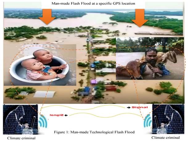
3. Results and Discussion
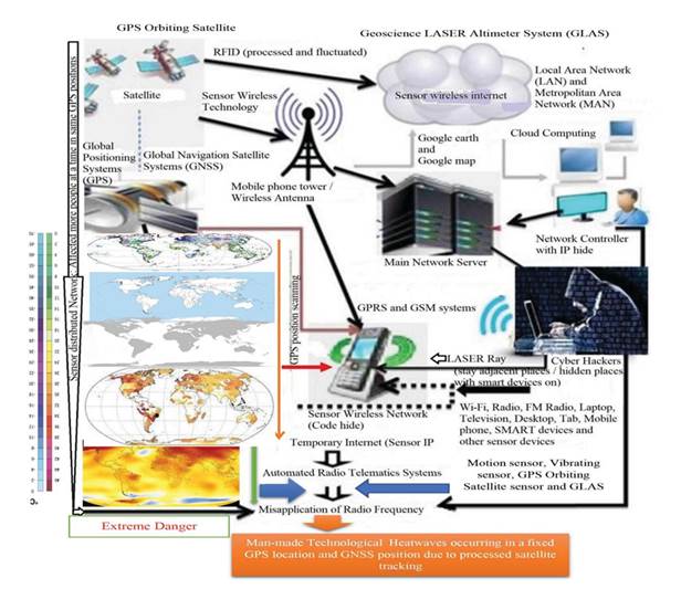
Studies
have shown various effects of man-made flash floods including pandemics at
specific GPS locations due to misuse of advanced satellite technology., which
as shown in Figure
1. The study
included different characteristics of sudden flash flood, such as:
(i) Sensor sinkhole, (ii) Sensor flash flooding, (iii)
Sensor cloud blocking, (iv) Sensor satellite Imaging, (v) Fixation of GPS
location selecting, (vi) Sensor land area fracturing, (vii) Flooded area
digital poisoning, (viii) Sensor water floating, (ix) Sensor electromagnetic
bubble, (x) Setting up Sensor sleeping among flooded people, (xi) Sudden
falling down and landslide, (xii) Sensor Thunder Storm, and (xiii) Digital
killing etc.
3.1. Sensor Sinkhole
The study showed the artificial sinkhole, which is created through tracking with advanced satellite technology (Figure 1). The study illustrated the sensor sinkhole enhanced water flow at the GPS location in man-made flash flood prone areas.
Figure 1
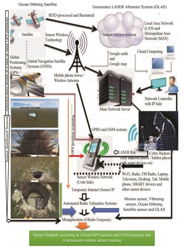
|
Figure 1 Sensor Sinkhole Due to Tracking with Advanced Satellite Technology |
3.2. Sensor Flash Flood
The study showed the sensor flash flood due to tracking with advanced satellite technology, which as shown in Figure 2. The study illustrated the sensor flash flood enhanced unexpected speedy water flow at the particular GPS location and floated everything from flood prone area to downstream.
Figure 2
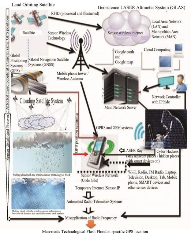
|
Figure 2 Man-Made Technological Flood Due to Tracking
Towards Clouds with Satellite Technology |
3.3. Electromagnetic Water Bubble
The study showed the electromagnetic water bubble due to tracking with advanced satellite technology, which as shown in Figure 3. The study illustrated the electromagnetic bubble due to creating an electromagnetic field, electromagnetic needle towards adjacent waterbody to enhance unexpected flash flood flow at the specific GPS location and flooded everything from upper stream area to downstream.
Figure 3
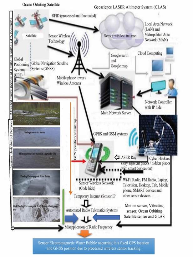
|
Figure 3 Sensor Electromagnetic Water Bubble Due to Tracking with Advanced Satellite Technology |
3.4. Man-made flash flood devastation
The study showed man-made flash flood devastation is dangerous due to increasing electromagnetic water bubbles with advanced satellite technology, which as shown in Figure 4. The flood prone area devastated everything from upper stream area to downstream due to unexpected flash flood flow at the specific GPS location.
Figure 4
|
Figure 4 Man-Made Flash Flood Devastating Scenery at Flood Prone Area |
It causes severe damage due to heavy or
excessive rainfall over a short period of time, usually less than 4-6 hours,
which is usually driven by strong currents after heavy rainfall. These flash
floods wash away riverbeds, wetland resources, culverts or bridges, urban roads,
or mountain canyons before anything gets in the way of public access to the
area. In
2022, an estimated 7.2 million people were affected by man-made engineered
flash floods and waterlogging in the nine northeastern
districts of Sylhet, Sunamganj, Moulvibazar,
Habiganj, Kishoreganj and Netrakona,
Brahmanbaria, Mymensingh and Sherpur
in Bangladesh Relief Web. (2022). Roads were
extensively damaged and the communication system was
disrupted accidentally. Severe food shortages occurred Floods caused
by cyclones are considered to be the worst disasters
in recent times. Many do not know the cause of this flood, many give wrong
information, and blame nature for this flood. Allah (God)
says: "I send down water from the sky in quantity, then I store it in the earth,
and I am able to remove it" (verse 18, Surah Al Mu'minun). As much water
as the earth's people, plants, animals and soil needs,
Allah (God) gives it through rain, neither less nor more - so that flash flood
is difficult for everyone to live. From this
study, it may be understood that rain is given by Almighty Allah, and harmful
floods are man-made through technology, which is known from research Miah et al. (2022).
Human
beings, plants, animals, and other living beings are not safe due to misuse of
advanced wireless sensor devices Parisha et al. (2022). Advanced
technology is inevitable for today’s world and more or less
everyone is dependent on this technology. But some
climate criminals misuse satellite technology to crush clouds moving at
specific GPS locations, the shattered clouds quickly melt and fall as rain on
the earth's surface. Cyber criminals create artificial floods and landslides in
specific areas by tracking wireless sensors in real time through active cloud
networks (Figure 5).
Figure 5

|
Figure 5
Man-Made Technological Landslide Due to Misuse of Advanced Satellite
Technology |
As long as the sensor
tracking device is switched-on when the network is active, rain will fall from
the sky according to the distributed radio frequency range. Again, a
group of cybercriminals spread false information about the source of the flood
on social media, spreading confusion among the general public. On the other
hand, the suffering of the people due to flash floods increased and new and wider
areas were inundated with flood water. On the other
hand, cybercriminals disrupt mobile phone and internet communications through
wireless tracking, leaving flood-prone areas isolated from social media, print
media and administration without outside help, and making it difficult to
rescue people and animals in flooded areas. In the midst of
the pandemic coronavirus crisis, this flood suddenly appeared as a blow to the
dead in certain areas. The whole world is going through an extreme crisis with
Corona, floods, digital crime, and heatwaves Miah et al. (2021) [Figure 6]. Cyber climate
criminals are an invisible enemy fighting against the pandemic coronavirus
disease at flood prone areas due to wireless tracking towards people and
animals. The
procession of people affected and killed due to various reasons is getting
longer day by day Miah et al. (2021), the
darkness is getting closer in the shadow of the cries.
Figure 6
|
Figure 6 Man-Made Technological Heatwave Due to Misuse of
Wireless Sensor Technology |
The challenge of the sudden climate
crisis is global. Studies have shown that the current crisis is a severe
man-made climate crisis due to misuse of advanced satellite technology,
resulting in flash-floods, cyclones, tornadoes,
landslides, heat waves and epidemic diseases. Although most people in the world
are not aware of these abuses, they are all closely related to advanced
technology and are limited in knowledge [Miah et al. (2022), Miah et al. (2022), Miah et al. (2021), Miah et al. (2022), Miah et al. (2022), Miah et al. (2023)]. The only way out of this crisis is to ensure secure wireless
sensor networks everywhere, enabling safe use, control of GPS sensors and
effective global navigation satellite systems. Higher authorities will ensure
legal action and speedy prosecution of climate criminals. It is essential to
form a coordinated task force for climate mitigation through safe technologies
with public participation, so that the present and future world is peaceful and
livable.
The flash-flood crisis is easy to mitigate with the CMAST model, which implies climate mitigation with advanced sensor technology Miah et al. (2021d). Climate department authorities can monitor man-made flood conditions through flush flood alarm sensor devices. In case of flash flood at GPS location, the flood crisis area will monitor through the network control unit and according to the monitoring report, all types of networks in the area especially wireless network, remote sensing satellite, telephone network, Wi. -Fi network and wireless sensor network will be completely shut down for 30 minutes If shut down, the cloud network system of climate criminals will also be shut down, thereby controlling floods, cyclones, earthquakes, tsunamis, volcanoes, landslides in the area. Due to effective monitoring, the existing weather office and security forces must be honest, dedicated, and brave, otherwise cyber criminals will conspire to appoint a member of the cybercriminal group to that position, so the crime of climate criminal will not be eradicated easily. All aspects of the environment, climate and technology sectors need to ensure the participation of competent people and be aware of this Miah et al. (2023), Miah et al. (2023), Miah et al. (2023).
Climate criminals Md Hatim Ali, Md Jasim Uddin, Nizam
Uddin, Candle Taj, and their associates will be arrested by the police
department and Interpol. The administration will give exemplary punishment so
that no other climate criminals can spread their influence. On the other hand,
the United Nations and its agencies will ensure safe satellite technology for
each member state.
4. Conclusion
Finally,
the study noted the misuse of advanced technology for flash flooding at
specific GPS locations. The study suggests future research trajectories for a
dynamic alternative approach to ensure safe advanced satellite technology
through effective means of sustaining the livelihoods of organisms linking to
national policies and the Sustainable Development Goals 2030.
5. Declaration
5.1. Data Availability
The data being
used to support the findings of this research work are available from the
corresponding author upon request.
CONFLICT OF INTERESTS
The authors declare no potential conflict of interests in this research work.
ACKNOWLEDGMENTS
The authors acknowledged the authority of Universiti of Malaysia Sarawak (UNIMAS), Malaysia for providing the Zamalah Postgraduate Scholarship for the completion of PhD degree. The authors are also grateful to the authority of the Information and Communication Technology Division, Ministry of Posts, Telecommunications and Information Technology, Government of People’s Republic of Bangladesh, for PhD Fellowship during the higher study in Malaysia. The authors acknowledged the authority of Northeast Medical College & Hospital (NEMCH), affiliated with Sylhet Medical University at Sylhet in Bangladesh for kind support. The authors also acknowledged the higher authority of the Department of Environment, Ministry of Environment, Forest & Climate Change, Government of People’s Republic of Bangladesh for providing the first prize 2022 in Sylhet Division for the Contribution on Environment Research.
REFERENCES
De Castro D., De Lima D.A.C., Romano, C. (2022). The Telecoupling Approach to the Global Food System and Climate Change Regime : The Pivotal Role of Brazil and China. In : Galanakis C.M. (eds) Environment and Climate-smart Food Production. Springer, Cham. https://doi.org/10.1007/978-3-030-71571-7_3
Miah, M. R., et al. (2021d). Unexpected Effects of Advanced Wireless Sensor Technology on Climate Change. World Environment, 11(2), 41-82. https://doi.org/10.5923/j.env.20211102.01
Miah, M. R., et al. (2022). Myths about Coronavirus : A Research Defense. Global Journal of Health Science, 14(2), 63–112. https://doi.org/10.5539/gjhs.v14n2p63
Miah, M. R., et al. (2022a). Towards the Misuse of Advanced Wireless Sensor Technology to Enable the Sudden Onset of ARDS. American Journal of Medicine and Medical Sciences, 12(6), 616-638. https://doi.org/10.5923/j.ajmms.20221206.05
Miah, M. R., et al. (2022b). Impact of Oscillated Wireless Sensor Networks to Initiate Cardiac Arrest. International Journal of Internal Medicine, 11(1), 1-46. https://doi.org/10.5923/j.ijim.20221101.01
Miah, M. R., Hasan, M. M., Parisha, J. T. & Chowdhury, S. H. (2022). Socioeconomic Impact of the Coronavirus Pandemic with Multiple Factors on Global Healthcare Policy. Journal of Politics and Law, 15(4), 242. https://doi.org/10.5539/jpl.v15n4p242
Miah, M. R., Hasan, M. M., Parisha, J. T., Shahriar, C. S., Sayok, A. K., Chowdhury, S. H. (2022). Adverse Global Health Impacts Due to the Proliferation of Man-Made Technological Heatwaves. Resources and Environment, 12(3), 67-75. https://doi.org/10.5923/j.re.20221203.01
Miah, M. R., Hasan, M. M., Parisha, J. T., Shahriar, C. S., Sayok, A. K., Selim, M. A., Chowdhury, S. H. (2023). A Scientific Innovative Approach to Recovery from Dengue Fever. Public Health Research, 13(1), 1-14. https://doi.org/10.5923/j.phr.20231301.01
Miah, M. R., Hasan, M., Miah, M. U., Parisha, J. T., Sher-E Alam, Sayok, A. K., Rahman, S., Sharif, A., Uddin, M. B. (2023). Innovative Policy to Enable Sustained Conserving of Forest Biodiversity. International Journal of Agriculture and Forestry, 13(1), 1-22. https://doi.org/10.5923/j.ijaf.20231301.01
Miah, M. R., Hasan, M., Parisha, J. T., Chowdhury, S. H., & Sayok, A. K. (2023). Misuse of Technology to Exacerbate Democracy in Crisis. American Journal of Sociological Research, 13(1), 12–23. https://doi.org/10.5923/j.sociology.20231301.03
Miah, M. R., Hasan, M., Parisha, J. T., Sayok, A. K., Sarok, A., Belal Uddin, M., Sher-E-Alam, Rahman, S., Miah, M. U., Sharif, A., Hossain, A. (2023). Biodiversity Information Systems in Geospatial Applications for Protected Area Management. American Journal of Geographic Information System, 12(1), 1–27. https://doi.org/10.5923/j.ajgis.20231201.01
Miah, M. R., Rahman, A. A. M. S., Sayok, A. K., Samdany, A. A. & Hannan, M. A. (2021h). How to Fight the COVID-19 Global Crisis. World Journal of Environmental Research, 11(2), 31–38. https://doi.org/10.18844/wjer.v11i2.5855
Miah, M. R., Sayok, A. K., Rahman, AAMS, Samdany, A. A., Akhtar, F., Azad, A. K., Hasan, MM, Khan, M. S., Alam,S. E., Alam, MS., Uddin, M. B., Abdullah, F., Shahriar, C. S., Shamsuddin, MAS., Uddin, M. B., Sarok, A., Rahman, IT., Chowdhury, SC., Begum, M. (2021). Impact of Sensor Networks on Aquatic Biodiversity in Wetland : An Innovative Approach, Geosciences, 11(1), 10-42. https://doi.org/10.5923/j.geo.20211101.02
Miah, M. R., Uddin, M. M., Parisha, J.T., Shahriar, C. S., Alam, M. S., Chowdhury, S. H., Nazim, A.Y.M., Hannan, M. A., Uddin, M. J., Uddin, M. B., Nipa, N. S., Khan, M. S., Ahmed, G., Hossain, M. S., Rashid, M. M., Samdany, A. A., Hossain, SAMI., Selim, M. A., Uddin, M. F., Nazrin, M. S., Azad, MKH., Malik, SUF., Hossain, M. M., Chowdhury, MAK., Tanjil, Y., Talukdar, MTH., Rahman, AAMS., Sayok, AK., Sharif, MA., Rahman, MS., Hasan, MM., Alam, MS., Uddin, MB., Patowary, D., min Bhuiyan, MRA., Md Towhid-ur-Rashid Chowdhury, MTR. (2023). Uncontrolled Advanced Wireless Sensor Technology to Enable Early Growth of Stomach Cancer. American Journal of Stem Cell Research, 5(1), 8-39. https://doi.org/10.5923/j.ajscr.20230501.02
Miah, R., Hasan, M. Parisha, J. T., Sayok, A. K. (2022). Challenges of Legal Instruments for Biodiversity Conservation along with National Parks. International Journal of Agriculture and Forestry, 12(3),79-101. https://doi.org/10.5923/j.ijaf.20221203.03
Miah, R., Hasan, M., Parisha, J. T., Sher-E Alam, Sayok, A. K., Sarok, A., Uddin, M. B. (2023). Enhancing National Park Information Knowledge to Improve Biodiversity Conservation in Bangladesh : A Study on Policy Perspectives. International Journal of Plant Research, 13(1), 1-23. https://doi.org/10.5923/j.plant.20231301.01
Miah, R., Hasan, M., Parisha, J. T., Sher-E-Alam, Sayok, A. K., Rahman, S., Sharif, A., Uddin, M. B., Chowdhury, S. H. (2022). Impact of Processed Wireless Sensor Networks on Biodiversity Conservation. International Journal of Biological Engineering, 7(1), 1-13. https://doi.org/10.5923/j.ijbe.20220701.01
Miah, R., Hasan, M., Parisha, J. T., Sher-E-Alam, Sayok, A. K., Rahman, S., Sharif, A., Uddin, M. B., Chowdhury, S. H. (2022). Innovative Policy Approach to Environmental Resource Management Through Green Banking Activities. American Journal of Economics, 13(2), 35-51. https://doi.org/10.5923/j.economics.20231302.01
Miah, R., Rahman, S., Khan, S., Hannan, M. A., Hossain, S., Chowdhury, S. S., Hossain, S. A. M. I., Talukdar, M. T. H., Samdany, A. A., Alam, M. S., Uddin, M. B., Sayok, A. K., Chowdhury, S. H. (2021). Effect of Coronavirus Worldwide through Misusing of Wireless Sensor Networks. American Journal of Bioinformatics Research, 11(1), 1-31. https://doi.org/10.5923/j.bioinformatics.20211101.01
Miah, R., Sher-E Alam, Hasan, M., Parisha, J. T., Sayok, A. K., Rahman, S., Sharif, A., Uddin, M. B. (2022). Scientific Environmental Governance to Accelerate Sustainable Biodiversity Management. Advances in Life Sciences, 1(1), 1-16. https://doi.org/10.5923/j.als.20221101.01
Osman, M. B., Tierney, J. E., Zhu, J., Tardif, R., Hakim, G. J., King, J., and Poulsen, C. J. (2021). Globally Resolved Surface Temperatures Since the Last Glacial Maximum. Nature 599, 239–244 (2021). https://doi.org/10.1038/s41586-021-03984-4
Parisha, J. T., Miah, M. R., Hasan, M. M., Begum, M. (2022). Impact of Environmental Pollution along with Technology for Conserving of Biodiversity. International Journal of Ecosystem, 12(1), 20-30. https://doi.org/10.5923/j.ije.20221201.02
Relief Web. (2022, August 2). Flash Flood in Northeastern Bangladesh. Relief Web, Bangladesh Office.
 This work is licensed under a: Creative Commons Attribution 4.0 International License
© Granthaalayah 2014-2023. All Rights Reserved.

