Promoting Biodiversity conservation with Supra-regional connections. Case study of a Mediterranean region, Tunisia
Safa Bel Fekih Boussema 1 ![]() , Marianne Cohen 2
, Marianne Cohen 2![]() , Faiza Khebour Allouche 3
, Faiza Khebour Allouche 3![]()
1 High Institute of Agronomic Science of
Chott Mariem, Department of Engineering and Landscape Planning, Sousse
University, B.P 47.4042 Chott Meriem Sousse, Tunisia
2 National Agronomic Institute of Tunis,
Lr Green Team (LR17AGR01), Carthage University, B.P 43, Avenue Charles
Nicolle 1082 Tunis Mahrajène, Tunisia
3 UMR Médiations, Sorbonne University,
Paris, France
|
|
|
ABSTRACT |
|
|
Ecological
network aims to ensure the survival of animal and plant species. It is
considered a new public policy to avoid the loss of biodiversity by
persevering the landscape connectivity and natural habitats from
fragmentation. This research proposes a methodology that is based on
identifying the sub-frames representatives of the study area and their
selected species. Thus, the methodology developed comprises five steps. In
the first step, the land use map was analyzed. Then, the major types of
habitats were extracted. In the third step, a forest habitats sub-frame, a
semi-open habitats sub-frame, and a wetlands sub-frame were determined. Then, the selected species were
characterized. Finally, supra-regional connections were proposed to enhance
biodiversity conservation in this region. As a result, crucial ecological
corridors can be optimized along with the proposed supra-regional connections
to the neighboring cities and contributing to promote sustainable projects.
Thus, the methodological approach developed can be a reference to other local
or regional studies. It can be integrated into planning documents that should
be a part of a decision-making perspective in public policies for sustainable
landscapes, preserving biodiversity, and enhancing well-being. |
|||
|
Received 11 July 2022 Accepted 12 August 2022 Published 25 August 2022 Corresponding Author Safa Bel
Fekih Boussema, belfekihsafa@gmail.com DOI 10.29121/granthaalayah.v10.i8.2022.4723 Funding: This research
received no specific grant from any funding agency in the public, commercial,
or not-for-profit sectors. Copyright: © 2022 The
Author(s). This work is licensed under a Creative Commons
Attribution 4.0 International License. With the
license CC-BY, authors retain the copyright, allowing anyone to download,
reuse, re-print, modify, distribute, and/or copy their contribution. The work
must be properly attributed to its author.
|
|||
|
Keywords: Sub-Frames, Species, Connections,
Sustainable, Planning |
|||
1. INTRODUCTION
In the context of rapid urbanization, urban areas continue to expand, and different policy makers have chosen strategies to prioritize the protection of ecological land. However, the concept of ecological network has been sparked by many researchers worldwide and therefore many countries have applied this concept: the United States Fábos (1995), Ahern (2002), Conine et al. (2004), Canada Hobden et al. (2004), Italy Toccolini et al. (2006), Portugal Machado (1995), Pena et al. (2010), Japan Asakawa et al. (2004) China Chang et al. (2012), Brazil Giordano et al. (2008), and Turkey Akpinar (2016). The ecological network includes natural and semi-natural areas that are important for the biodiversity preservation, and the ecological corridors connecting them. However, it is structured into a set of sub-frames, reservoirs of biodiversity and corridors that connect them. According to Sordello et al. (2017), a sub-frame is defined by a set of spaces, more or less connected, made up of habitats with common characteristics and able to accommodate particular species. The reservoirs or core areas are the areas in which biodiversity is best represented and where species can carry out all or part of their life cycle such feed, reproduce and rest Linglart et al. (2016). These areas are interconnected by corridors that constitute functional links Arnould et al. (2011) allowing the circulation of species between different habitats Clergeau and Désiré (1999). Specifically, in Mediterranean region, different applications of ecological network have been applied. As an example, in Italy, the Lambro River Valley Greenways Systems consist in planning a network for connections between public parks, natural areas, historic sites and other open spaces Toccolini et al. (2006) In Portugal, Pena et al. (2010) have studied the development of ecological network for the Metropolitan Lisbon Area, with an interdisciplinary approach that provides an assessment of the relationship between landscape structure and landscape dynamics. Mainly, a significant attention is now being paid to ecological network Lamond and Everett (2019). It is due to their recreational, environmental, economic, and social functions, as well as other benefits to the cities in which they were implemented Lindsey et al. (2001). In this breath, Tunisian cities especially coastal ones are marked by a significant urban extension, which led to the fragmentation of landscapes and the degradation of living environment; this is the case of Sousse city. The main objective of this work is to; i) demonstrate the useful of the ecological network planning in reducing landscape fragmentation and the loss of natural habitats, and ii) strengthen regional and supra-regional connectivity.
2. Materials and methods
2.1. Study area
Figure 1 presents the Sousse region, which is located in the Tunisian Sahel and covers an area of 2308 Km². It has a population of 416 330 inhabitants INS (2017) and includes nine delegations: Sousse Sidi Abdel Hamid, Sousse Riadh, Sousse Medina, Sousse Jawhara, Hammam Sousse, Akouda, Sidi BouAli, Hergla and Enfidha. The climate in the study area, belong to the lower semi-arid bioclimatic stage. It is characterized by a hot and dry summer, and a soft and humid winter. Thus, the annual average rainfall is about 200 mm; and the annual average temperature is about 18.6 °C. Sousse region is marked by economic, environmental, ecological, and cultural importance. Also, it provides the diversity of landscapes, namely forest, coastline, rural, urban, industrial, and natural, hence its rich flora and fauna Boussema and Khebourallouche (2020).
Figure 1
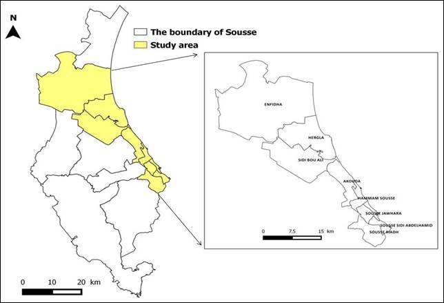
|
Figure 1 Localization Map of the Study Area |
3. Methodology
In the aim of this research, the methodology is broken down to five steps. The first one is based on the analysis of the land use map of the study area. The second one presents the reclassification work necessary to form the major habitats. The third consist of the determination of sub-frames. In the fourth step, a study of species is carried out. At the end, the supra-regional connections are defined.
3.1. Determination of Sub-frames
The definition of sub-frames is done through taking into account the different natural environments present in the study area. Thus, this first step is to define the composition of each one by affecting all land cover classes potentially useful to biodiversity to at least one sub-frame. The identification of the representative sub-frames of Sousse region is extracted from the Land use map of the INFOTEL Data Base (DB) 2017. It was modified after it has been collected from the IFPN (2010).
3.2. Determination of representative species
In addition to the land use data, naturalist and ecological data relating to the target species were also used, from inventories and observations made by the agents of GDF (2018) or naturalists from partner structures or field checks. The aim was to select species representative of the different sub-frames studied so that a functional network could be set up Silvano et al. (2017). Each of the selected species is also intended to be representative of a group of species with similar ecological requirements. Also, we have referred to the Red List of Endangered Species of International Union for Conservation Nature IUCN (2020).
4. Results
4.1. Land use of Sousse region
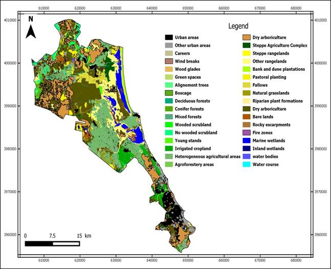
The INFOTEL DB 2017 contains a series of information corresponding to the distribution of forests, extent, type of reforestation, type of vegetation, etc. IFPN (2010). It is of major interest for our study, as it is the most recent detailed land use layer that has been recovered. It contains 32 land use classes Figure 2. The landscape of the Sousse region is dominated by urban areas; cultivated areas (irrigated cropland, dry arboriculture, heterogeneous agricultural areas, etc.); forests (deciduous, conifer, mixed); rangelands (steppe); grasslands; and wetlands (marine and inland). The rangelands are located in the north near the dry arboriculture; in the center near the wetlands and cultivated soils; and in the south near the urban areas. The cultivated soils are located on the north side and in the center. For irrigated cropland are at the level of Enfidha city. The distribution of urban areas between the north and the south of the region is not homogeneous. Along the shoreline, these areas are compact and formed a ribbon habitat. On the northwest side, an urban mass which correspond to the center of Enfidha city and surrounded by small villages. Whereas, in the middle, the city of Hergla is on the coast while Sidi Bouali is rather inside. In the south, the city of Sousse is presented and formed the largest urban center in the whole region. Forests are located in the north and south of the study area. Wetlands are totally represented by sebkha on the northeast side, the middle and on the south.
Figure 2
|
Figure 2 Land Use Map of Sousse Region (@INFOTEL 2017) |
4.2. Major types of habitats and associated sub-frames of Sousse region
Based on the different land use classes, eight major types of habitats have been defined such as: forests, shrub plantations, grasslands, rangelands, water courses, water bodies, riparian forests, and wetlands. Then, three sub-frames are highlighted: a forest habitats sub-frame, a semi-open habitats sub-frame and wetlands sub-frame Table 1.
Table 1
|
Table 1 Major Types of Habitats and Associated Sub-Frames of Sousse Region |
|||
|
Land
use classes |
Major
types of habitats |
Sub-frames |
|
|
Deciduous
forests |
Forests |
Forest |
|
|
Conifer
forests |
|||
|
Mixed
forests |
|||
|
Boscage |
Wooded
scrubland |
Shrub
plantations |
|
|
Windbreaks |
Young
stands |
||
|
Wood
glades |
Alignment
trees |
||
|
Steppe
rangelands |
Rangelands |
Semi-open |
|
|
Other
rangelands |
|||
|
Natural
grasslands |
Grasslands |
||
|
Water
courses |
Water
courses |
Wetlands |
|
|
Water
bodies |
Water bodies |
||
|
Riparian
plant formations |
Ripisylves |
||
|
Bank
and dune plantations |
|||
|
Marine
wetlands |
Wetlands |
||
|
Inland wetlands |
|||
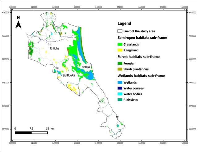
4.3. Typology of sub-frames identified in Sousse region
The site, oriented northeast-southwest, is characterized
by a mosaic of environments of uneven areas and diverse natures. They are
located in the middle and northwest (coastal side) and practically
interconnected, which gives a singular value to the natural heritage of the
territory. Figure 3 shows that three
sub-frames were identified: a forest habitats sub-frame, a semi-open habitats
sub-frame and a wetlands habitats sub-frame. The forest habitats sub-frame
consists of two main types of habitats, forests, and shrub plantations; the
same thing for the semi-open habitats sub-frame which contains two types of
habitats, namely the rangelands and grasslands; whereas the wetlands sub-frame
occupies four types of habitats: water courses, water bodies, riparian forests,
and wetlands. However, the semi-open sub-frame occupies the largest area, about
30 % and consists in different environments scattered on the northwest side
particularly at the level of Enfidha. In the middle, they are more condensed
especially at the level of the delegations of Hergla and Sidi Bouali. And some
environments persist on the southwest side. The forest sub-frame is smaller in
size, and the habitats are more numerous in the northwest and weakly on the
opposite side. The wetland sub-frame is particularly limited at the level of
the coasts and sebkhas.
Figure 3
|
Figure 3 Sub-Frames of Sousse Region and Their Habitats |
4.4. Reference species selected
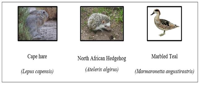
Three representative species were chosen respectively: Cape hare, North African Hedgehog and Marbled Teal Figure 4.
Figure 4
|
Figure 4 Reference Species Selected for The Development of GBI of Sousse Region
(www.iucn redlist.org) |
The first specie is representative of the forest sub-frame since the Hare is a forest mammal. It is well suited to living in arid and desert environments. However, it is threatened by a number of predators and its mortality is linked to weather conditions, nutritional deficiencies and road traffic. Delibes-Mateos et al. (2010) explained other reasons related to urbanization, increased hunting, intensive agriculture, and increased use of pesticides and fertilizers. Currently, the IUCN Red List lists the species as a Minor Concern Villafuerte and Delibes-Mateos (2019).
For the semi-open habitats sub-frame, the Hedgehog is a mammal that occupies grasslands or forest edges but prefers hedged-rich habitats Hubert (2008). It is therefore a species which take open environments as their habitats. At night, the male moves on 0.5 to 25 ha and the female on 0.5 to 10 ha Vaucher (2013) which is adapted to the scale of our study area. Increases in the number of roads and habitat loss are the most serious threats to the Hedgehog. This species is listed in Appendix II of the Berne Convention and in Appendix IV of the European Union Directive on Habitats and Species Amori et al. (2008).
The Marbled Teal has been mobilized as a representative wetland species. It is a dispersive and partially migratory species Del et al. (1992). It is able to disperse in search of suitable habitat at any time of the year under changing conditions Kear (2005). It is adapted to wetlands in semi-arid region Green and Silva (2007) and breeds in dry steppes areas on shallow or alkaline freshwater ponds with well vegetated shorelines Green (1993), and rich emergent and submerged vegetation Kear (2005). It is legally protected in Tunisia, and it is inscribed on the IUCN Red List under the status of Critically Endangered (Bird Life International 2017).
4.5. Supra-regional connections proposed
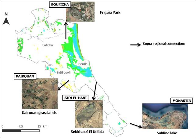
The three sub-frames of the Sousse region are identified and carried out on a regional scale. It highlights on the functional and potential ecological habitats for the species already selected. On the other hand, supra-regional connections are proposed so that Sousse region will be interconnected with neighbouring regions such as Bouficha, Kairouan, Sidi El Hani and Monastir; and even be part of a national context. For these reasons, various proposals are presented in Figure 5, i) a connection to the north of the region can be established with the forests of Bouficha. While the forests of the study area are in the north, links with the forests of the Bouficha delegation are possible knowing that the city is home to the only animal park in the entire Sahel region known as Friguia Park, with a considerable area equal to 30 ha. ii) A connection to the middle can be established between the sebkha of Halq El Mingel and the Sebkha of El Kelbia situated in Sidi El Hani, which has been classified as a Ramsar site since 2007, and this connection is made through the water course that connects the two sebkhas. Also, a connection with the Kairouan grasslands is possible, since the city of Kairouan is located at 50 km from Sousse and is recognized by its grasslands and farmlands. iii) A connection can be created in the south with the Sousse sebkha and the Sahline lake which is located in southwest of Monastir city.
Figure 5
|
Figure 5 Supra-Regional Connections Proposed in This Study |
5. Conclusions
The spatial organization of the constituent environments of Sousse region has resulted in eight main types of habitats: forests, shrub plantations, grasslands, rangelands, water courses, water bodies, ripisylves and wetlands. The compilation of these environments has allowed the formation of three pioneering sub-frames of the green and blue infrastructure: a forest habitats sub-frame, a semi-open habitats sub-frame and a wetlands sub-frame. However, the semi-open sub-frame is dominated by its constituent environments, occupying 30% of the study area. Research on animal species present in the study area, their distribution, their characteristics and their vulnerability revealed three representative species which are subservient to these types of environments: Cape hare for the forest habitats sub-frame, North African Hedgehog for the semi-open habitats sub-frame and Marbled Teal for the wetlands sub-frame. So, the sub-frames identified, and the supra-regional connections proposed in this research can be considered as a new way of space structuration rather than as a new tool to freeze the economic and societal development of Tunisia and similar countries in Mediterranean region. It is about building a future where it forms one of the pillars of sustainable development.
Conflicts of Interests
The authors declare no conflict of interest.
ACKNOWLEDGMENTS
None.
REFERENCES
Ahern, J. (2002). Greenway a Strategic Land scapé Planning : Theory and Application. Dissertation, Wageningen University, The Netherlands, 179.
Akpinar, A. (2016). Factors Influencing The Use of Urban Greenways: A Case Study of Aydin, Turkey. Urban Forestry and Urban Greening, 123-131. https://doi.org/10.1016/j.ufug.2016.02.004
Amori, G., Hutterer, R., Kryštufek, B., Yigit, N., Mitsain, G., and Palomo, L.J. (2008). Atelerixalgirus. Liste rouge de l'UICN des espèces menacées 2008.
Arnould, P., Le Lay, Y., Dodane, C. and Méliani, I (2011). Nature in the City and Unlikely Biodiversity. Geography, economy, society, 13, 45-68.
Asakawa, S., Yoshida, K., and Yabe, K. (2004). Perceptions of Urban Stream Corridors Within the Greenway System of Sapporo, Japan, 167-182. https://doi.org/10.1016/S0169-2046(03)00158-0
Boussema, S., Khebourallouche, F. (2020). Methodology of Land Use Mapping to Landscape Typology Applied to the Enfidha Region, Tunisia. International Journal of Innovation And Scientific Research, 52 (1), 8-19.
Chang, Q., Li, X., Huang, X., And Wu, J. (2012). A GIS-Based Green Infrastructure Planning For Sustainable Urban Land Use And Spatial Development. Procedia Environmental Sciences,12,491-498. https://doi.org/10.1016/j.proenv.2012.01.308
Clergeau, P., Désiré, G. (1999). Biodiversity, Landscape And Planning : From The Corridor To The Biological Connection Zone. Mappemonde, 55, 19-23.
Conine, A., Xiang, W.N., Young, J., and Whitley, D. (2004). Planning for Multi-Purpose Greenways In Concord, North Carolina. Landscape and Urban Planning, 68 (2-3), 271-287. https://doi.org/10.1016/S0169-2046(03)00159-2
Del Hoyo, J., Elliot, A., and Sargatal, J. (1992). Handbook of the Birds of the World, Ostrich to Ducks.Lynxedicions, Barcelona, Spain,1.
Delibes-Mateos, M., Farfán, M.A, Oliveros, J., And Vargas, J.M. (2010). Land-Use Changes as a Critical Factor for Long-Term Wild Rabbit Conservation in the Iberian Peninsula. Environmental Conservation, 37(2),169-176. https://doi.org/10.1017/S0376892910000214
Fábos, J.G. (1995). Introduction and Overview : The Greenway Movement, Uses and Potentials of Greenways. Landscape and Urban Planning, 33(1-3),1-13. https://doi.org/10.1016/0169-2046(95)02035-R
GDF (2018). Identification Form of El Madfoun Forest. Genaral Directory of Forests of Sousse Region, 13.
Giordano, L.D.C., Riedel, P.S. (2008). Multi-Criteria Spatial Decision Analysis Fordemarcation Of Greenway : A Case Study of The City of Rio Claro, Sao Paulo,Brazil. Landscape and Urban Planning, 84(3-4), 301-311. https://doi.org/10.1016/j.landurbplan.2007.09.006
Green, A.J., Selva, N. (2000). The Diet of Post-Breeding Marbled Teal Marmaronettaangustirostris and Mallard Anasplatyrhynchos in the Goksu Delta, Turkey. Revue d'Ecologie (La Terre Et La Vie), 55(2), 161-169.
Hobden D.W, Laughton G.E, Morgan K.E (2004). Green Space Borders, A Tangible Benefit?Evidence from Four Neighbourhoods in Surrey, British Colum-Bia, 1980-2001. Land Use Policy, 21(2), 129-138. https://doi.org/10.1016/j.landusepol.2003.10.002
Hubert, P. (2008). Effects of Urbanization on Population of European Hedgehogs.Dissertation, Reims Champagne-Ardenne University, 124.
IFPN (2010). Results of the Second National Forestry and Pastoral Inventory. National Centre For Mapping And Remote Sensing, 171.
INS (2017). Monthly Statistical Bulletin (December 2017). National Institute of Statistics Tunisia,15.
Kear, J. (2005). Ducks, Geese and Swans Volume 2 : Species Accounts (Cairina to Mergus). Oxford University Press, Oxford, U.K.
Lamond J., Everett, G. (2019). Sustainable Blue-Green Infrastructure : A Social Practice Approach to Understanding Community Preferences and Stewardship. Landscape and Urban Planning. 191(10), 36-39. https://doi.org/10.1016/j.landurbplan.2019.103639
Lindsey, G., Maraj, M., and Kuan, S. (2001). Access, Equity, and Urban Greenways: An Exploratory Investigation. Prof. Geogr. 53(3),332–346. https://doi.org/10.1111/0033-0124.00288
Linglart, M., Morin, S., Paris, M., And Clergeau, P. (2016). Implementation Methodology of an Urban Green Network : The Case of an Urban Association, Plaine Commune. Cybergeo : European Journal of Geography.
Machado, J.R. et al. (1995). Metropolitan Landscape Planning : a Greenway Vision for the LisbonMetropolitan Area (AML). Special Issue Landscape, 95-103.
Pena, S.B., Abreu, M.M., Teles, R., and Espirito-Santo, M.D (2010). A Methodology for Creating Greenways Through Multidisciplinary Sustainable Landscape Planning.Journal of Environmental Management, 91(4), 970-983. https://doi.org/10.1016/j.jenvman.2009.12.004
Silvano, A.L., Guyer, C., Steury, T.D., and Grand, J.B. (2017). Selecting Focal Species as Surrogates for Imperiled Species Using Relative Sensitivities Derived from Occupancy Analysis. Ecological Indicator, 73,302-311. https://doi.org/10.1016/j.ecolind.2016.09.043
Sordello, R., Billon, L., Amsallem, J., and Vanpeene, S (2017). Technical and Scientific Report on The Development of Regional Ecological Coherence Schemes.Methods for Identifying the Components of TVB.TVB Resource Center, P.104.
Toccolini, A., Fumagalli, N., and Senes, G. (2006). Greenways Planning In Italy : The Lambro River Valley Greenways System, 98-111. https://doi.org/10.1016/j.landurbplan.2004.09.038
Vaucher, P. Y. (2013). Small Mammals. The European Hedgehog.
Villafuerte, R., Delibes-Mateos, M. (2019). Oryctolaguscuniculus. Liste rouge de l'UICN des espèces menacées 2019. http://dx.doi.org/10.2305/IUCN.UK.2019-3.RLTS.T41291A45189779.en.
 This work is licensed under a: Creative Commons Attribution 4.0 International License
© Granthaalayah 2014-2022. All Rights Reserved.