CLASSIFICATION OF VEGETATION OF LOWER TANAWAL, PAKISTAN BY CLUSTER ANALYSIS ON THE BASIS OF ALTITUDEAdeela Bibi 1 1 Department of Botany, Hazara University Mansehra-21300, Pakistan2 Department of Botany, Government Post Graduate College Abbottabad, Pakistan |
|
||
|
|
|||
|
Received 3 December 2021 Accepted 1 January 2022 Published 31 January 2022 Corresponding Author Adeela
Bibi, adeelabibiresearch@gmail.com DOI 10.29121/granthaalayah.v10.i1.2022.4454 Funding:
This
research received no specific grant from any funding agency in the public, commercial,
or not-for-profit sectors. Copyright:
© 2022
The Author(s). This is an open access article distributed under the terms of
the Creative Commons Attribution License, which permits unrestricted use, distribution,
and reproduction in any medium, provided the original author and source are
credited.
|
ABSTRACT |
|
|
|
During
this research study on the basis of altitude 5 altitudinal ranges were formed
from 2396 to 6742 ft. from Lower Tanawal, Abbottabad Pakistan. From these 05 altitudinal ranges 17 plant
communities were established, 3 plant communities were documented from
altitudinal range I (2396-3054 ft). Four plant communities were formed from
altitudinal range II (3142-3613 ft). Three plant communities were recognized
from altitudinal range III (3708-4182 ft). Four plant communities were
recorded from altitudinal range IV (4220-4666 ft). Three plant communities
were established from altitudinal range V (4827-6742 ft). The ordination
techniques Two-way Indicator Species Analysis (TWINSPAN) were used to
classify the data. |
|
||
|
Keywords: TWINSPAN,
Vegetation, Cluster Analysis, Lower Tanawal 1. INTRODUCTION Cluster analysis is a
classification technique for placing similar objects into clusters. The
cluster analysis is used to place similar samples into clusters, which are
arranged in a hierarchical structure called a dendrogram. Clustering is the
process of data by combining similar objects to form small classes, then
combining small classes into larger classes Pielou (1984). Cluster
analysis was used to form and identify similar groups among sampling units,
to classify the sampling units into numerous groups according to similar
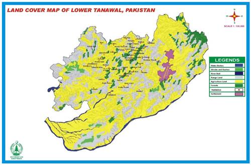
vegetation structure, Hoon (2010). Study Area The Lower Tanawal
located in District Abbottabad Khyber–Pakhtunkhwa Pakistan. It lies between the 34° 12' 32 and 34° 15´
76 north latitude to 73° 09' 398 and 73° 03´ 316 east longitudes Bibi et al. (2019). The Lower
Tanawal is part of the Lesser Himalayas. The Lesser Himalayas comprise on
whole area of Hazara division Hussain and Illahi
(1991). |
|
||
|
|
|
Figure 1 Map of Lower Tanawal Showing Location of Stands |
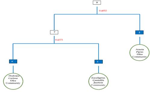
2. TWINSPAN CLASSIFICATION OF THE
ALTITUDINAL RANGE 1 (2396-3054 FT.)
TWINSPAN were used for the
classification of samples and species. In this classification 9 stands and 72
species were observed. The data was classified into two groups. In division 1 the eigenvalue 0.40 was noted. Seven stands were placed in negative group (*0)
whereas two stands were in positive group (*1). In division 2 the eigenvalue was
0.43. In division
2 (7) 1 stand was positioned in negative group (*00) whereas 7 stands
were positioned in positive group (*01). Then based on indicator species 3 plant communities Eucalyptus-Cannabis–Justicia community, Dodonaea-Carissa–Olea community and Acacia-Pyrus-Olea were documented from altitudinal range 2396-3054 ft
(Figure 2).
|
|
|
Figure 2 TWINSPAN
Classification of vegetation from the Altitudinal Range I of Lower Tanawal,
Pakistan |
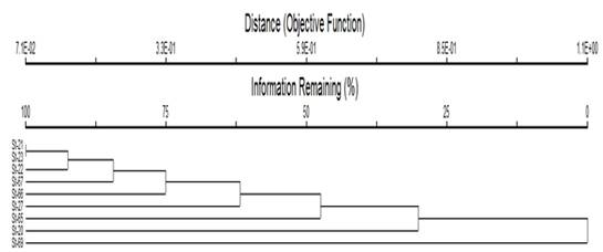
Cluster
Analysis of the Altitudinal Range 1
The Cluster Analyses was done by
using the method of PC-ORD version 5 which converted 9 stands into 3 plant
communities (Figure 3).
|
|
|
Figure 3 Cluster analysis of the vegetation of Altitudinal
Range I of Lower Tanawal, Pakistan |
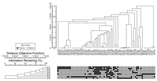
Two-Way
Cluster Analysis
The two-way cluster analysis
showed distribution of plant species into different stands. The dandrogram
identified the presence and absence of plant species in different stands. The
black dots have presented the presence while white bubbles shown absence of
species in the stands. TWCA dandrogram shown that Dodonaea
viscose was present in 08 stands out of 09 stands whereas Ziziphus nummularia was present in 07 stands
which showed wide range of distribution of these species at an altitudinal range 2396-3054 ft whereas Asparagus officinalis,
Morus alba, Anagallis arvensis,
Lantana camara, Opuntia ovata and Xanthium
stromarium present in one stand which indicated narrow range of
distribution of these species at
altitudinal range1. Three plant communities were
recognized from 09 stands having 72 plants species (Figure 4).
|
|
|
Figure 4 Two Way Cluster Analyses of the vegetation
of Altitudinal Range I of Lower Tanawal, Pakistan |
Eucalyptus-Cannabis–Justicia
Community
Eucalyptus
globulus, Cannabis sativa and Justicia
adhatoda community were noted from locality of Khan
Thathera at the elevation of 3054 ft. In
this community 01 stand and 32 plant species were noted. In this community Eucalyptus globulus with IV (8.66), Cannabis sativa
IV (8.24) and Justicia
adhatoda IV (7.50) were dominant plant species. At
this elevation temperature was 36.4, wind speed 0.3, humidity 40.1, dew point
22.3, Heat index 38.5 and barometer pressure was 853.2. Soil of this locality was clay loam.
Dodonaea-Carissa–Olea
Community
Dodonea
viscosa, Carissa opaca and
Olea ferruginea community were noted from Khalabut, Thathi
Kamila, Beri, Chamhad, Fateh Bandi and Shadial between the elevations of 2396–3025
ft. This community has 06 stands and 128 plant
species. The dominant plant was Dodonaea viscosa having
IV (21.12), Carissa opaca, IV
(7.84) and Olea ferruginea
IV (6.48). At these elevations temperature range was 33.4
to 37.2 wind speed 0.1 to 0.3 humidity 34.3 to 40.2, dew point 16.1 to 22.3,
Heat index 23.7 to 38.5 and barometer pressure was 831.2 to 865.2. Soil of these localities was loam.
Acacia-Pyrus-Olea
Community
This
community was recorded from Bachha Sani and Purani Patheri between elevations of 2522-3014
ft. This community has 02 stands and 40 plant species. The dominant plant
species in this community were Acacia modesta with IV (9.54) Pyrus pashia (8.65) and Olea
ferruginea (5.71). In these two localities temperature range was
35.1 to 37.2 wind speed 0.1 to 0.3 humidity 34.3 to 39.2, dew point 16.1 to
24.3, Heat index 23.7 to 36.5 and barometer pressure was 831.2 to 867.2.
Soil of these localities was loam.
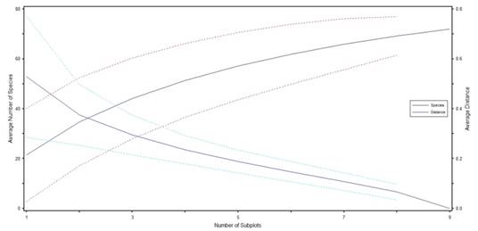
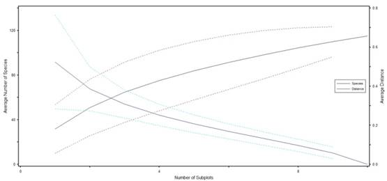
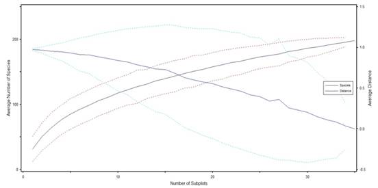
Species Area Curve
Species area curve describes the
relationship between number of species and number of stands. PC-ORD version 5
was used to draw species area curve. It indicated that with an increase in the
number of stands the number of species also increases. The diagram indicated
that stand 6 shown maximum numbers of species up to stand 9 when number of
species increase the species curve distance become zero (Figure 5).
|
|
|
Figure 5 Species
area curve of the vegetation of Altitudinal Range 1 of Lower Tanawal,
Pakistan |
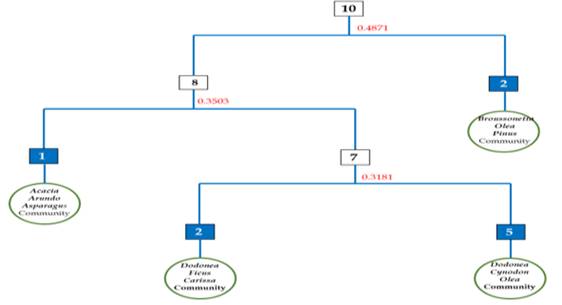
3. TWINSPAN Classification of the Altitudinal Range II (3142-3613 ft.)
There were 10 stands and 115 species.
The data were classified into two groups. In
division 1 the eigenvalue was 0.48. Eight stands were positioned in negative group (*0)
whereas 2 stands were placed in positive group (*1). The eigenvalue was 0.35 in division 2. In division 2 (8) 1 stand was
positioned in negative group (*00)
while 7 stands were positioned in positive group (*01).
The eigenvalue was 0.31 in division 3
(7). In this division 2 stands were positioned
in negative group (*10)
while 5 stands were located in positive group (*11). The 04 plant communities
Dodonaea-Ficus-Carissa community, Acacia-Arundo-Asparagus community, Dodonaea-Cynodon-Olea community, and Broussonetia-Olea-Pinus community were
formed (Figure 6).
|
|
|
Figure 6 TWINSPAN Classification of vegetation from
the Altitudinal Range II of Lower Tanawal, Pakistan |
Cluster Analysis
of the Altitudinal Range II
The Cluster Analysis was done
which shown cluster of 10 stands into 04 plant communities (Figure 7).
|
|
|
Figure 7 Cluster analysis of the
vegetation of Altitudinal Range II of Lower Tanawal, Pakistan |
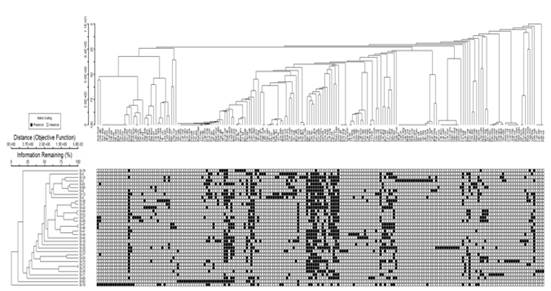
Two-Way Cluster Analyses
The two-way
cluster analysis showed distribution of plant species
into different stands on the basis of presence and absence (1,0). The two-way
cluster analysis dandrogram indicated that Oxalis corniculata was present in 10
stands and Cynodon dactylon was
present in 09 stands which shown wide range of distribution of these species at an altitudinal range 3142 to 3613 ft, whereas Trifolium repens,
Viburnum cotinifolium, Ipomoea carnea, Mirabilis jalapa, Sedum sarmentosum,
Senecio aquaticus and Scrophularia dentate were present in 01 stand which
indicated narrow range of distribution of these species from altitudinal range II. The following four plant
communities were recognized from 10 stands with 115 species (Figure 8).
|
|
|
Figure 8 Two Way
Cluster Analyses of the vegetation of Altitudinal Range II of Lower Tanawal,
Pakistan |
Dodonaea-
Ficus-Carissa Community
This community
was recognized from Chamhad and Chakar Pain between the elevations of 3142-3202
ft. In this community 02 stands and 37
plant species were noted. Dodonaea
viscosa with IV (15.87) Ficus palmata, (5.30) and Carissa
opaca (4.96) were the dominant species. At these
elevations temperature range was 34.4 to 37.5 wind speed 0.1 to 0.3 humidity
34.3 to 54.2, dew point 22.3 to 23.5, Heat index 23.7 to 35.5 and barometer
pressure was 831.2 to 857. 2. Soil
of these localities was loam.
Acacia-Arundo-Asparagus
Community
This community was documented from Banseri at the
elevations of 3468 ft. In this community 01 stand and 21 plant species were
documented. Acacia
modesta have IV (48.45), Arundo donex, (8.07) Asparagus
officinalis (8.05) were the dominant species. At this elevation
temperature range was 32.2, wind speed 0.1, humidity 34.1, dew point 26.1, Heat
index 24.7 and barometer pressure was 832.2. Soil of these localities was loam.
Dodonaea-Cynodon-Olea
Community
This community was recorded from Bandi Darah, Jabbi, Naradoga,
Thalian, and Khuliala between the elevations of 3327-3613 ft. In this community
total 05 stands and 151 species were recognized. Dodonaea viscosa with IV (13.57), Cynodon dactylon (8.50) and Olea ferruginea (4.71) were
the dominant species. At these elevations temperature range was 33.4 to 37.2
wind speed 0.1 to 0.3 humidity 34.1 to 40.2, dew point 25.7 to 27.3, Heat index
37.3 to 38.5 and barometer pressure was 823.2 to 854.2. Soil of these localities was loam.
Broussonetia-Olea-Pinus
Community
This community was noted from
Shahkot and Kamhar bandi between elevations of 3353-3418 ft. In this community 02
stands and 78 plant species were noted. Broussonetia papyrifera having IV (19.63), Olea ferruginea (4.42), Pinus roxburghii (3.99) were
the dominant species. At these elevations temperature range was 28.3. to 32.2
wind speed 0.2 to 0.3 humidity 33.3 to 35.2, dew point 13.9 to 22.3, Heat index
30.2 to 36.5 and barometer pressure was 865.2 to 899.2. Soil of these localities was loam.
Species Area Curve
Species area curve describes the relationship
between number of stands and number of species. It states that when number of
stands increasing the plant species also increase. The diagram indicates that
stand 5 indicated maximum numbers of plant species up to stand 10 (Figure 9).
|
|
|
Figure 9 Species area curve of the
vegetation of Altitudinal Range 1I of Lower Tanawal, Pakistan |
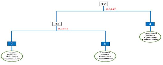
4. TWINSPAN Classification of the Altitudinal Range III (3708-4182 ft.)
In this classification 17 stands and
182 species were recorded. The data were classified into two groups. In division 1 the eigenvalue
was 0.31. The 13 stands were placed in negative grouped (*0)
while 04 stands were positioned in positive group (*1). In division 2 (13) 7 stands were
positioned in negative group (*00)
whereas 6 stands were placed in positive group (*01) and in this division the eigenvalue was 0.25. Then 3 plant communities Prunus-Pinus-Dodonea community, Pinus-Punica-Dodonaea community and Dodonaea-Acacia-Cynodon
community were
recognized (Figure 10).
|
|
|
Figure 10 TWINSPAN Classification of vegetation from
the Altitudinal Range III of Lower Tanawal, Pakistan |
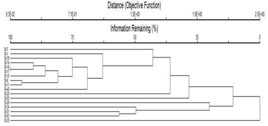
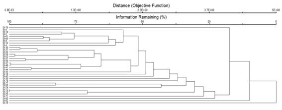
Cluster Analysis
of the Altitudinal Range III
The Cluster Analyses by using
PC-ORD was done which grouped 17 stands into 3 plant community having 182
plants species (Figure 11).
|
|
|
Figure 11 Cluster analysis of the
vegetation of Altitudinal Range III of Lower Tanawal, Pakistan |
Prunus-Pinus-Dodonea Community
It was recorded from Siyal,
Sherwan Khurd, Thoray, Kakot, Rakran and Gali Syedan between elevations of
3708-4152 ft. There were 6 stands and
107 species. Prunus
amricana IV (26.64) Pinus roxburghii (6.23) and Dodonaea
viscosa (5.23) were the dominant species. At these
elevations temperature range was 34.3 to 35.2 wind speed 0.1 to 0.2 humidity
33.3 to 42.2, dew point 13.8 to 22.3, Heat index 29.2 to 33.5 and barometer
pressure was 865.2 to 887.2. Soil
of these localities was clay loam.
Pinus-Punica-Dodonaea
Community
This community
was noted from Garamri and Patheri between elevations of 3892-4182 ft. In this
community 07 stands and 122 plant species were noted. Pinus roxburghii IV
(5.77) Punica granatum (4.77) Dodonaea
viscosa with IV (4.54) were
the dominant plant species. At these elevations temperature range was 28.4. to
32.2 wind speed 1.1 to 0.3 humidity 39.3 to 42.2, dew point 17.9 to 22.3, Heat
index 30.2 to 34.5 and barometer pressure was 861.2 to 885.2. Soil of these localities was loam.
Dodonaea-Acacia-Cynodon
Community
This community was recognized
between elevations of 3789-4161 ft. from Kotnali, Jabri, and Mukdabi. There
were 04 stands and 72 plant species. Dodonaea
viscosa have IV (17.57), Acacia modesta (11.66) and Cynodon dactylon with IV (6.83) were
the dominant plant species. At these elevations temperature range was
29.3 to 34.2, wind speed 0.1 to 0.2, humidity 33.3 to 39.2, dew point 13.9 to
21.3, Heat index 33.2 to 37.5 and barometer pressure was 833.2 to 866.2. Soil of these localities was loam.
Species Area Curve
It states that when number of
stands increasing the plant species also increase. The diagram showed that
after stand 8 maximum number of plant species appear, and new species
continuously appear up to stand 17 (Figure 12).
|
|
|
Figure 12 Species area curve of the vegetation of
Altitudinal Range III (3708-4182 ft.) of Lower Tanawal, Pakistan |
5. TWINSPAN
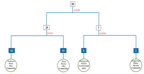
Classification of the Altitudinal Range IV (4220-4666 ft.)
This classification had shown 35 stands
and 201 plant species. The data were classified into two groups. Twenty-eight stands were positioned in
negative group (*0) while seven stands were positioned in
positive group (*1). The eigenvalue
was
|
|
|
Figure 13 TWINSPAN Classification of vegetation from
the Altitudinal Range IV of Lower Tanawal, Pakistan |
Cluster Analysis of the Altitudinal
Range IV
In this Cluster Analyses 35
stands grouping into 4 plant communities were observed (Figure 14).
|
|
|
Figure 14 Cluster
analysis of the vegetation of Altitudinal Range IV of Lower Tanawal, Pakistan |
Two-Way Cluster Analyses
In this analysis four plant communities
were documented from 35 stands with 201 species. The TWCA dandrogram indicated that Olea ferruginea, Berberis lycium, Punica granatum, were present in more
than 20 stands while Caryopteris odorata,
Symplocos recemosa, Gymnosporia royleana and Polygala vulgris present in one stand which indicated narrow range of distribution of these
species in an
elevation 4220 to 4666 ft (Figure 15).
|
|
|
Figure 15 Two Way Cluster Analyses of the vegetation of
Altitudinal Range IV of Lower Tanawal, Pakistan |
Pinus-Punica-Olea
Community
This community was documented from Takia Hal,
Sargal, Pawa, Khanda Khoo, Pindkargu, Patiyan, Sherwan Kalan, Thathi Faqeer
Sab, Panduthana, Poona, Soban Gali and Chetri, between elevations of 4267-
Debregessia-Punica-Oxalis
Community
This
community was noted from Mundarra, Panduthana,Karmatti,
Thathi Faqeer Sb, Mubaraak and Patheri
Sydan at an elevations of 4220-4629 ft. This community have 06 stands and 108
plant species. The dominant plant species were Debregessia salicifolia with IV (5.27) Punica granatum (3.93) and Oxalis corniculata with IV (3.44). Soil of these localities was clay loam. At these elevations
temperature range was 29.3 to 34.2, wind speed 0.1 to 0.2, humidity 33.3 to
39.2, dew point 13.9 to 21.3, Heat index 33.2 to 37.5 and barometer pressure
was 831.2 to 866.2.
Dodonaea-Pinus-Olea
Community
This community was noted from Kotha Doga, Panduthana, Sargal, Sando Gali, Darah, Bain Gojre, Soben
GalIi, Panyali, Habibabad, Kangrora, Khalkhater, and Chariala, between elevations of 4239-
Polygonum-Rubus-Mentha
Community
This community was noted from elevation of 4385 ft. In this community, 01 stand
and 28 plant species were noted. The dominant plant species were Polygonum viviparum
(43.84), Rubus ellipticus (38.14) and
Mentha longifolia
(37.93). Soil of these
localities was clay loam. At these elevations temperature range was
29.3 to 32.2, wind speed 0.1 to 0.2, humidity 33.3 to 37.2, dew point 13.9 to
21.3, Heat index 33.2 to 36.5 and barometer pressure was 833.2 to 867.2.
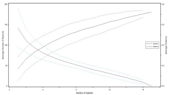
Species Area Curve
The diagram indicated that after stand
15 maximum number of species appear and new species continuously appear up to
stand 35 (Figure 16).
|
|
|
Figure 16 Species area curve of the vegetation of
Altitudinal Range IV of Lower Tanawal, Pakistan |
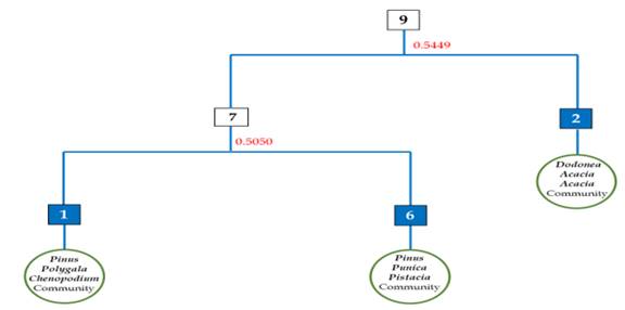
6. TWINSPAN
Classification of the Altitudinal Range V (4827-6742 ft.)
This classification has 101 plant
species and 9 stands. The data were classified into 02 groups. In division 01 the eigenvalue
was 0.54 and 07 stands
were placed in negative groups (*0) while 02 stands were
placed in positive group (*1). In division
02 (7) 1 stand was placed in negative group (*00) while 06 stands were
placed in positive group (*01).
In division 02 the eigenvalue
was 0.50. The 3 plant communities Pinus-Punica-Pistacia
community, Pinus-Polygala-Chenopodium
community and Dodonaea-Acacia-Acacia community
were formed. (Figure 17).
|
|
|
Figure 17 TWINSPAN Classification of vegetation from
the Altitudinal Range V of Lower Tanawal, Pakistan |
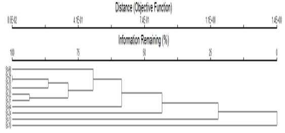
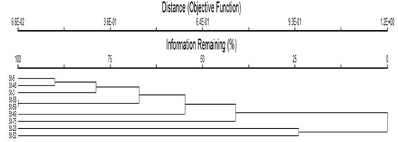
Cluster Analysis
of the Altitudinal Range V
The Cluster Analyses classified 9
stands into 3 plant communities (Figure 18).
|
|
|
Figure 18 Cluster analysis of the vegetation of
Altitudinal Range V of Lower Tanawal, Pakistan |
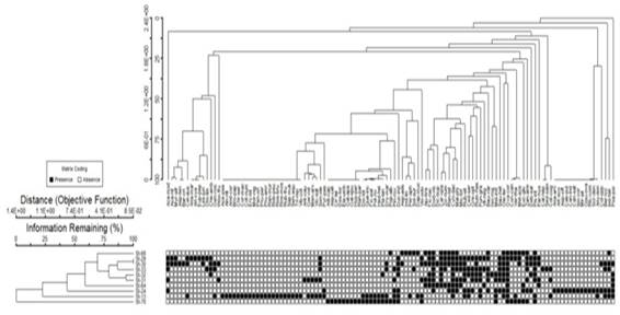
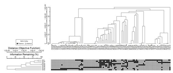
Two-Way Cluster Analyses
The dandrogram showed that Isodon
rugosus and Berberis lycium, were
present in 07 stands while, Trichodesma
indicum, Cissampelos pareira, Acacia mearnsii, Delbergia sisso, Indigofera
linifolia, Tridax procumbens and
Cotoneaster melanocarpus were present in 01 stand which indicated narrow
range of distribution of these species. At these elevations temperature range was
29.3 to 34.2, wind speed 0.1 to 0.2, humidity 33.3 to 39.2, dew point 13.9 to
21.3, Heat index 33.2 to 37.5 and barometer pressure was 833.2 to 866.2.
Three plant communities were
documented from 09 stands having 101 plants species (Figure 19).
|
|
|
Figure 19 Two Way Cluster Analyses of the vegetation
of Altitudinal Range V of Lower Tanawal, Pakistan |
Pinus-Punica-Pistacia Community
In this community 06 stand
and 73 plant species were noted. Pinus
roxburghi with IV
(15.84), Punica granatum (5.57), Pistacia integerrima (5.55), were
dominant. This community was
noted from the localities of Bagarian, Thana, Paswal, Sandogali and Thallay
between the elevations of 4827-5480 ft. Soil of these localities was clay loam. At these elevations
temperature range was 30.1 to 34.2, wind speed 0.2 to 0.3, humidity 32.3 to
39.2, dew point 13.9 to 18.3, Heat index 33.2 to 37.5 and barometer pressure
was 834.2 to 867.2.
Pinus-Polygala-Chenopodium
Community
Pinus
roxburghii, Polygala vulgaris, Chenopodium vulgare community were noted at the
elevations of 6742 ft. In this community
there were 01 stand and 24 plant species. Pinus roxburghi (34.13) Polygala vulgaris (7.36) Chenopodium vulgare (5.71) were
dominant plant species. Soil of these
localities was loam. At these elevations
temperature range was 29.3 to 33.2, wind speed 0.1 to 0.2, humidity 34.3 to
39.2, dew point 13.9 to 21.3, Heat index 32.2 to 37.5 and barometer pressure
was 833.2 to 888.2.
At these elevations temperature range was 29.3 to 34.2, wind speed 0.1 to 0.2,
humidity 33.3 to 39.2, dew point 13.9 to 21.3, Heat index 33.2 to 37.5 and
barometer pressure was 833.2 to 866.2.
Dodonea-Acacia-Acacia Community
This community was documented
from Todomira, Jarral between the elevations of 4952-
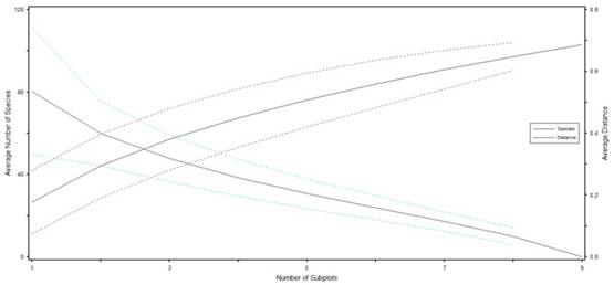
Species Area Curve
The diagram indicated that stand 05
shown maximum number of plant species up to stand 09 (Figure 20).
|
|
|
Figure 20 Species area curve of the vegetation of
Altitudinal Range V of Lower Tanawal, Pakistan |
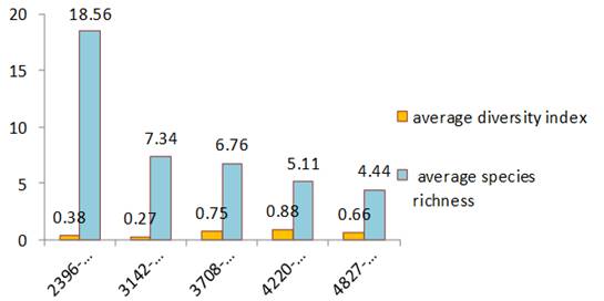
7. AVERAGE SPECIES RICHNESS AND DIVERSITY INDEX
From the 5 altitudinal range average species
richness and average species diversity were noted. The maximum species richness
(18.56) was noted from the altitudinal range 2396-3054.Minimum species richness
(4.44) was noted from altitudinal range 4827-6742. The maximum diversity index
(0.88) was documented from 4220-4666. Minimum diversity index 0.27 was recorded
from 3142-3613 (Figure 21).
|
|
|
Figure 21 Average diversity index and species richness with
altitude |
8. DISCUSSION
TWINSPAN were used for the
classification communities on the basis of altitudinal ranges.
The two-way cluster analysis shown the distribution of plant species
into numerous stands based on presence and absence of species.
Five altitudinal ranges were formed, and 17 communities were documented from
these altitudinal ranges. From altitudinal range 2396-3054
ft. from 09 stands with 72 species 03 plant communities were documented. Result
shown that Dodonaea viscosa have wide
range of distribution due to presence in maximum stands of this altitudinal
range.
From altitudinal range 3142-3613
ft. 04 communities were documented from 10 stands and 115 plant species. Result
shown that Oxalis corniculata and Cynodon dactylon indicated wide range of
distribution in this range. At this range (3708-4182 ft.) 03 communities were
recognized with 182 species from 17 stands.
At altitudinal range (4220-4666
ft.) 04 plant communities from 35 stands with 201 plant species were noted. The result shown that Olea ferruginea and Punica granatum
have wide range of distribution. From altitudinal range 4827-6742 ft 03
communities were formed from 9 stands with 101 plant species. The result shown Isodon rugosus showed wide range of distribution. Ahmed et
al. (2009a) noted that cluster analysis
classified different plant communities in Himalayan Forest of Pakistan. The
similar findings were showed by Mehmood
et al. (2015) who documented 06
plant communities by using cluster analysis and TWCA in the forest of District
Torghar. Our results are agreed with Bokhari
et al. (2016) who stated 06 associations by
using cluster analyses in Pine Forest of Azad Kashmir. Our results are similar to Amjad et
al. (2014a) who described 13 plant
communities which merged in to 04 plant associations by using cluster analysis.
These results are also in line with Ahmed et al. (2010) who stated 03 plant
groups from forest of Azad Kashmir by using cluster analysis. Our results are agreed
with Baruch (2005) who documented many plant communities and merged them into
few groups by using cluster analysis.
From the altitudinal range 2396-3054 ft. maximum species richness (18.56) was documented. The minimum species richness (4.44) was noted from altitudinal range 4827-6742 ft. The maximum diversity index (0.88) was documented from 4220-4666 ft. Minimum diversity index 0.27 was noted from 3142-3613 ft. Our results are agreed with Malik et al. (2003) who identified that at higher altitude there were high species diversity and at lower altitude low species diversity was recorded in the area of Dao Khun, Kashmir. Our findings are also similar with Malik et al. (2012) who noted that diversity and altitude have correlation in Bedori Hills and Ganga Choti of Azad Jummu and Kashmir. Many phytosociological studies showed that with altitude species richness decreased Currie and Francis (2004), Brown and Lomolino (1998).
REFERENCES
Ahmed, M., N. Khan, M. Wahab, S. Hamza, M.F. Siddique, K. Nizim and M.U. Khan. (2009a). Vegetation structure of Olea ferruginea forests of lower Dir District of Pakistan. Pak. J. Bot., 40(6) : 2683-2695. Retrieved from https://www.cabdirect.org/cabdirect/abstract/20103234322
Amjad, M. S., M. Arshad, A. Rashid, S. K. Chaudhari, N. Z. Malik and S. Fatima. (2014a). Examining relationship between environmental gradients and 234 Lesser Himalyan forest vegetation of Nikyal valley, Azad Jammu and Kashmir using ordination analysis. Asi. Pac. J. Trop. Med., 7 (Suppl 1) : 610-616. Retrieved from https://doi.org/10.1016/S1995-7645(14)60297-2
Bibi, A. Z. Iqbal, G.M. Shah. (2019). Floristic diversity, biological spectrum of Lower Tanawal, KP, Pakistan. Ukr. J. Ecol., 4 (9) : 505-514. Retrieved from https://doi.org/10.15421/2019_782
Bokhari, T. Z., Y. Liu, M. Ahmed, M. F. Siddiqui, Q. Li and Z. U. Khan. (2016). Multivariate analysis of some pine forested areas of Azad Kashmir, Pakistan. Pak. J. Bot., 48(1) : 105-113.
Bokhari, T. Z., Y. Liu, M. Ahmed, M. F. Siddiqui, Q. Li, Z. U. Khan and S. A. Malik. (2016). Multivariate analysis of some pine forested areas of Azad Kashmir, Pakistan. Pak. J. Bot., 48(1) : 105-113.
Brown, J.H. and M.V. Lomolino. (1998). Biogeography.2nd Ed. Sunderland, Massachusetts (Sinauer Associates, Inc. Publishers). pp.691. Retrieved from https://academic.oup.com/jmammal/article/80/4/1385/852047?login=true
Currie, D.J. and A.P. Francis. (2004). Regional versus climate effect on taxon richness in angiosperms ; reply to Qian and Ricklefs. Am. Nat.,163(5) : 780-785. Retrieved from https://doi.org/10.1086/383596
Hoon,s (2010) The Classification of Forest Communities by Cluster Analysis in Mt. Seokbyung Experimental Forest of Gangwon-Do Jour. Korean For. Soc. Vol. 99, No. 5, pp. 736~743. Retrieved from https://www.koreascience.or.kr/article/JAKO201034952232541.page
Hussain, F., and I. Illahi. (1991). Ecology and Vegetation of Lesser Himalayan Pakistan. Botany Department University of Peshawar, pp. 187.
Malik, Z.H., F. Hussain and N.Z. Malik. (2012). Life form and leaf size spectra of plant communities Harbouring Ganga Chotti and Bedori Hills during 1999-2000. Int. J. Agric. Biol., 9(6) : 833-838. Retrieved from https://www.researchgate.net/profile/Z-Malik/publication/242139950_Life_form_and_Leaf_Size_Spectra_of_Plant_Communities_Harbouring_Ganga_Chotti_and_Bedori_Hills_During_1999-2000/links/55769f7108ae7521586c3590/Life-form-and-Leaf-Size-Spectra-of-Plant-Communities-Harbouring-Ganga-Chotti-and-Bedori-Hills-During-1999-2000.pdf
Mehmood. A., A.H. Shah., S.M. Khan, A.H. Shah, I. Rehman and H. Ahmad. (2015). First floristic exploration of the district Tor Ghar, Khyber Pakhtunkhwa, Pakistan. Pak. J. Bot., 47(SI) : 57-70. Retrieved from https://www.researchgate.net/profile/Azhar-Mehmood/publication/301625823_FIRST_FLORISTIC_EXPLORATION_OF_THE_DISTRICT_TORGHAR_KHYBER_PAKHTUNKHWA_PAKISTAN/links/571e495d08aead26e71a8614/FIRST-FLORISTIC-EXPLORATION-OF-THE-DISTRICT-TORGHAR-KHYBER-PAKHTUNKHWA-PAKISTAN.pdf
Pielou, E.C. (1984). The interpretation of ecological data- A primer on classification and ordination. John Wiley and Sons. USA
 This work is licensed under a: Creative Commons Attribution 4.0 International License
© Granthaalayah 2014-2022. All Rights Reserved.