
|
|
|
|
Hybrid PWA Navigation System for College Campuses
Nivedita Vibhandik 1![]() , Pranav Kawale 2
, Pranav Kawale 2![]() , Mayuresh Sonar 2
, Mayuresh Sonar 2![]() , Mrunal
Divate 2
, Mrunal
Divate 2![]() , Aditya
Sonar 2
, Aditya
Sonar 2![]()
1 Assistant
Professor, Department of Computer Engineering, Sandip Institute of Technology
and Research Centre, Nashik, India
2 B.E
Department of Computer Engineering, Sandip Institute of Technology and Research
Centre, Nashik, India
|
|
|
ABSTRACT |
|
|
In our college
we have seen that big campuses are often confusing to move around, specially for new students, visitors and also for people
who are differently abled. Normal GPS apps are fine for outdoor navigation
but they don't really work when it comes to inside the buildings and complex
routes of campus. So we started working on a Hybrid
Progressive Web App (PWA) system, where we combine GPS for outdoor routes
along with BLE beacons, WiFi, QR codes for indoor
areas. While designing, we kept focus more on accessibility like adding voice
assistance and wheelchair friendly paths, also on safety with emergency exits
and campus security alerts. Another part we added was context aware
navigation like giving option for less crowded paths, shaded areas or well lit routes. During our
testing with students we saw that the accuracy
indoor was close to 1–2 meters, also it saved time and users reported better
satisfaction compared to only GPS based systems. From this we believe our
approach can really be used in actual campus deployment. |
|||
|
Received 05 August 2025 Accepted 02 September 2025 Published 23 October2025 Corresponding Author Nivedita
Vibhandik, nivedita.vibhandik@sitrc.org
DOI 10.29121/ijetmr.v12.i10.2025.1683 Funding: This research
received no specific grant from any funding agency in the public, commercial,
or not-for-profit sectors. Copyright: © 2025 The
Author(s). This work is licensed under a Creative Commons
Attribution 4.0 International License. With the
license CC-BY, authors retain the copyright, allowing anyone to download,
reuse, re-print, modify, distribute, and/or copy their contribution. The work
must be properly attributed to its author.
|
|||
|
Keywords: Hybrid
Navigation System, Progressive Web Application (PWA), Indoor Positioning
System (IPS), Outdoor Navigation (GPS), Wi-Fi Fingerprinting; Crowd-Aware
Routing, Smart Campus Applications, Seamless Indoor-Outdoor Localization,
User-Centric Navigation |
|||


1. INTRODUCTION
The campuses of colleges and universities are not small anymore, they almost feel like mini-cities with so many different buildings, roads, hostels and facilities spread around. For a fresher or a visitor it becomes confusing and sometimes even frustrating to reach the correct place, whether it's a class, lab, hostel, canteen, library or an event hall. Even staff and event people struggle when they are not familiar with the campus map. Common apps like Google maps are fine for outdoors, but they don't really work when moving inside buildings, which is actually a very important part of the campus environment. They also don't handle campus specific needs like blocked areas, construction zones, accessibility routes or in case of emergencies. So we saw there is a clear need for a campus based navigation system.
1.1. Progressive Web Applications (PWAs)
In the last few years Progressive Web Applications (PWAs) have become a good alternative to normal mobile apps. PWAs mix the cross platform reach of the web with features of native apps like offline use, notifications and also device hardware like GPS, etc. They are easy because they don't need app store download and they run on many devices. This is very useful on campus where people use different phones and systems. But while checking existing studies, we found most of them focus only on outdoor or only on indoor navigation, there was no proper hybrid system combining both. Also accessibility and emergency features are mostly ignored even though they are very important to keep campus inclusive and safe
1.2. Proposed Hybrid PWA Navigation System
Because of this gap we are working on a Hybrid PWA Navigation System. Our idea is to overcome limits of current systems by putting together multiple technologies in one platform. GPS will be used outdoors while indoors will use BLE beacons, WiFi, QR codes to improve accuracy. Apart from accuracy, we are focusing on inclusivity with features like voice assistance, haptic feedback and wheelchair friendly routes so that everyone, including people with special needs, can use it.
1.3. Emergency Support Features
Another key feature is emergency support. During fire, earthquake or any such events the app will auto guide users to the nearest safe exit and also connect with campus security for fast response. We also added context aware navigation so users can choose not only the shortest path but also other options like less crowded, safer or more eco friendly routes.
1.4. Testing and Research Objectives
We plan to test this Hybrid PWA system on real users in campus and check how well it performs in terms of accuracy, time and usability. With this work we aim to contribute not just in navigation technology but also in the bigger vision of smart campuses where tech improves everyday life, makes the place inclusive and increases safety for all members of the academic community.
2. Literature Survey
2.1. Existing Campus Navigation Approaches
When we started looking into campus navigation, we noticed that most research really goes into indoor tracking methods. Things like Bluetooth Low Energy (BLE) beacons, WiFi fingerprinting, QR code scans or sometimes even camera based positioning. They are fine when you are inside a building, but the big issue is that they don’t really connect well with outdoor navigation. And since in a
campus people keep moving between one building to another, that becomes a real problem. Another thing we saw is that these systems usually forget about people with disabilities, and they don’t really talk much about how such tech could help during emergencies in a big campus setup.
For example, PEOPLEx (2023) or BLE-PDR with floor plans (2025) managed to get very good accuracy, around 1–2 meters. Still, those systems were not built exactly for college environments, so they sometimes lack scalability, simplicity and also inclusivity. And in many papers the main focus is technical accuracy, while user-friendliness is not given the same importance. We think this creates a big gap, because students and staff need something easy to use, not just technically impressive.
2.2. Progressive Web Applications in Navigation
While checking other tech options, we came across Progressive Web Apps (PWAs). They feel like a very good alternative compared to heavy mobile apps, since they run on any device, work offline, and don’t take much space because there’s no need to download big installation files. Just open them in the browser or save to the home screen and they work. This alone makes them much easier to adopt by students, which matches what Blessing (2024) and Thomas and Kumar (2024) also said about user adoption. We also found that PWAs are already used in other areas like education tools, gamified learning or sharing resources (SIGCSE, 2023). But when it comes to navigation, especially a hybrid indoor-outdoor system for a big campus, there’s not much research. And one more thing that is missing is their role in emergencies. For example, a PWA could easily push a fire drill alert or natural disaster warning, but this is rarely talked about. So here we see a need for PWAs in navigation systems that don’t just work but are also context-aware and reliable when it really matters.
2.3. Hybrid Indoor-Outdoor Navigation Technologies
We also checked the literature on hybrid approaches that mix different positioning methods. Indoor localization itself is already studied a lot, with BLE, WiFi and also Ultra Wideband (UWB) being very common. BLE and WiFi are easy to deploy and cheap, but usually only give 2–5 meters accuracy, which is not enough for detailed indoor maps. UWB on the other hand is very precise, like 10–30 cm (Leitch, 2023), but it comes with high cost and also energy issues, so not everyone can use it. To solve this, many hybrid models were proposed, for example combining BLE with IMU sensors, or fusing multiple sensors together with floor plan data. These systems reduce error drift and sometimes go down to 1–2 meters accuracy Pan et al. (2025). But again, most of them care only about technical performance. They don’t really think about how students move around, or how accessibility and safety could be built into such systems. That’s where we feel there’s a missing piece: hybrid navigation that is strong technically but also socially inclusive.
2.4. Research Gap
After reading through all this, we realised that while there’s a lot of progress in indoor, outdoor and hybrid navigation separately, not much is done to combine everything into a single, student-centered platform. Especially, the link between PWAs and hybrid navigation is almost untouched, even though the potential is big for making systems more accessible and scalable. Also, hardly any paper looks into emergency situations or disability support as a core feature, which is something very important for a campus setup. So, in our research we are trying to fill this space by designing a PWA-based hybrid navigation system. Our aim is to make it accurate, simple to use, aware of context and also ready to send alerts in case of an emergency. Basically, we want something that goes beyond just showing your location, into something that improves safety, inclusivity and real practicality for students and staff in day to day campus life.
3. Methodology
For our project we decided to make the navigation system as a hybrid Progressive Web Application (PWA). The main reason was PWA works on many devices, can be used offline and it does not force students to install heavy apps. The way we designed it is modular. Each part has its own function but all of them connect together.
3.1. Frontend Design
We used React to build the frontend and also added service workers for offline features. The UI is kept simple but also has options like voice guide, bigger font text, and high contrast themes for users who have vision problems. We even added AR overlay and QR code scan as backup in places where the internet is weak.
3.2. Backend Framework
Backend is made with Node.js and we used PostGIS database for spatial querries. This handles map storage, routes, schedules and events. It also has APIs that can give realtime info like crowd density and emergency arts.
3.3. Hybrid Navigation Module
The Outdoor side is handled by GPS. For indoors we rely on BLE beacons and wifi fingerprints. We combine these with each other so that moving between indoor and outdoor feels seamless
Emergency & Accessibility Module:
Here we focused on things that are often ignored. This module can suggest wheelchair friendly paths (ramps, lifts, step free ways). In emergency it quickly shows nearest safe exit and can also notify security. We added speech synthesis to give realtime voice guidance.
Context-Aware Routing Engine:
We implemented A* search with adaptive weights. So apart from shortest distance it can also consider safety, congestion, lighting and slope. Users can select different options like fastest route, eco-friendly, or accessible.
3.4. Data Collection
To make and test the system we had to gather multiple kind of data.
Campus Infrastructure Mapping:
We digitalized classrooms, labs, hostels, libraries, cafeteria, event places and exits. Then we created a graph-based map where nodes are locations and edges are paths.
Indoor Positioning Data:
BLE beacons were setup in crowded halls, classrooms and stair areas. WiFi signal strengths were collected from campus routers. QR codes were placed at junctions and entrances for redundancy.
User Movement Data:
We also collected anonymous logs of how people moved during pilot testing. From this we estimated crowd density and congestion at different times.
3.5. Prototype Implementation
A prototype
using this stack:
· Frontend: React PWA with service workers.
· Backend: Node.js, REST API and PostGIS for spatial data.
· Map Layer: Vector maps made with Mapbox GL JS.
Features included in prototype:
· Voice navigation with Web Speech API.
· Wheelchair routing that prefers ramps and lifts.
· Offline access to maps & schedules.
· Emergency routing mode with realtime exits.
3.6. System Architecture
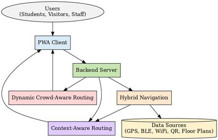
Figure 1
|
Figure 1 System Architecture of - Hybrid PWA Navigation System for College Campuses |
The system architecture can be seen in the diagram. Users like students, staff and visitors connect through the PWA client, which works on any device and links with the backend server. The server handles data from GPS, BLE beacons, WiFi, QR codes and floor plans. Using this info, the hybrid navigation helps move smoothly between indoor and outdoor places. Crowd-aware routing avoids rush areas and context-aware routing adds safety, comfort and accessibility like ramps or lifts. Together, these modules make the system more simple, reliable and user friendly for campus navigation.
4. Conclusion
So, the system architecture we made can be explained from the diagram itself. The users, like students, staff and also visitors, mainly use the system through the PWA client which works on almost any device. This PWA is linked with the backend server that manages the flow of data and other service parts. The system takes data from many sources like GPS, BLE becons, WiFi signals, QR codes and even floor plans of campus. With the help of this data the hybrid navigation part helps users to move smoothly between indoors and outdoors. Along with that, the crowd-aware routing keeps check of busy areas and suggests alternate routes so people don’t get stuck in rush. The context-aware routing also adds more smartness, by thinking about comfort, safety and also accessibility like ramps or lifts. In this way, all the modules and data sources are connected together so the system can give more reliable, user friendly and also accurate navigation inside the campus.
CONFLICT OF INTERESTS
None.
ACKNOWLEDGMENTS
None.
REFERENCES
Blessing, M. (2024). Progressive web Apps (PWAs) and their Impact on user Experience. University Press.
Leitch, S. G., Ahmed, Q. Z., Abbas, W. B., Hafeez, M., Laziridis, P. I., Sureephong, P., & Alade, T. (2023). On indoor localization using WiFi, BLE, UWB, and IMU technologies. Sensors, 23(20), 8598. https://doi.org/10.3390/s23208598
Pan, W., Yang, Y., Chen, M., Wei, D., Guo, C., & Mao, S. (2025). Fusing Bluetooth with Pedestrian Dead Reckoning: A Floor Plan-Assisted Positioning Approach. arXiv Preprint, arXiv:2504.09905.
Pierre-Yves Lajoie, Bobak Hamed Baghi, Sachini Herath, François Hogan, Xue Liu, & Gregory Dudek. (2023). PEOPLEx: PEdestrian Opportunistic Positioning Leveraging IMU, UWB, BLE and WiFi. arXiv preprint arXiv:2311.18182.
Thomas, A. J., & Kumar, S. R. (2024). A Study on Progressive web Apps: Revolutionizing user Experiences and Redefining web Applications. ShodhKosh: Journal of Visual and Performing Arts, 5(6).
|
|
 This work is licensed under a: Creative Commons Attribution 4.0 International License
© IJETMR 2014-2025. All Rights Reserved.