
|
|
|
|
GEOGRAPHIC INFORMATION SYSTEM MAPPING BANTEN MAKING SERVICES IN DENPASAR CITY
Ni Nyoman Supuwiningsih 1![]()
![]() ,
Keisha Abelia Arifa 2
,
Keisha Abelia Arifa 2![]() , Ni Kadek Karlina Lestariani 3
, Ni Kadek Karlina Lestariani 3![]()
1 Computer
System, ITB STIKOM Bali, Indonesia
2 Informatics
Management, ITB STIKOM Bali, Indonesia
3 Digital
Business, ITB STIKOM Bali, Indonesia
|
|
|
ABSTRACT |
|
|
The majority
of Bali's population is Hindu. Hinduism is a religion that uses offerings as
a means to carry out prayers. Currently, women in Bali in particular who
usually have the task of making offerings are already actively working
outside the home all day so they don't have much time to make offerings as a
means of ceremony so it doesn't rule out the possibility of buying offerings
according to their needs, there is a lack of information regarding location
and information regarding The existence of offerings making services,
especially in Denpasar City as the capital of Bali province, is a problem
being faced. This lack of information can cause difficulties for people who
actively work outside the home to provide the financial aid needed for
ceremonies. Initial research was carried out by distributing several
questions to residents of the city of Denpasar which were given randomly. The
results of this research stated that around 90% of the community really
needed information about banten making services due to the lack of time in
the process and the complexity of making banten which is used as a means of
appropriate ceremonies. each other's needs. Based on these problems, it is
necessary to develop an internet-based Geographic Information System for
Mapping Banten Manufacturing Services in Denpasar City using internet-based
Geographic Information System software, namely Google My Maps so that it can
be accessed online by the people of Denpasar in particular. After this system
is built, a trial will be carried out on the community to assess the
feasibility of the software in the form of a questionnaire using the Guttman
scale, data analysis using the feasibility percentage technique. The research
method uses field methods (field research). Product trials use the usability testing
method, user trials use the feasibility percentage formula. It is hoped that
the resulting digital map will help the people of Denpasar city to easily
obtain information about the services for making offerings that are spread
across so that problems in providing offerings for ceremonies can be made
available quickly without having to take time off work. |
|||
|
Received 02 April 2024 Accepted 04 May 2024 Published 07 June 2024 Corresponding Author Ni Nyoman
Supuwiningsih, ninyomansupuwiningsih@gmail.com
DOI 10.29121/ijetmr.v11.i6.2024.1459 Funding: This research
received no specific grant from any funding agency in the public, commercial,
or not-for-profit sectors. Copyright: © 2024 The
Author(s). This work is licensed under a Creative Commons
Attribution 4.0 International License. With the
license CC-BY, authors retain the copyright, allowing anyone to download,
reuse, re-print, modify, distribute, and/or copy their contribution. The work
must be properly attributed to its author.
|
|||
|
Keywords: Geographic
Information Syatem, Banten Services, Denpasar City, Digital Map, Google My
Maps |
|||

1. INTRODUCTION
The majority of
Bali's population is Hindu. Hinduism is a religion that uses offerings as a
means to carry out prayers. The word upakara consists of two words, namely upa
which means surroundings or something related to, and kara which means hand. So
upakara means everything made by hands, in other words a means of offering that
comes from hard work. Banten is also called wali so the Dewa Yadnya ceremony is
also called pujawali. The word wali contains the meaning wali means
representative and wali means returner. Wali, which means representative,
contains a philosophical symbolic meaning that the offering is a representative
of the contents of the universe created by God Dewi (2020).
Every ceremony
held in Bali requires facilities in the form of donations according to its
respective type and function. Banten consists of several types according to
their levels, such as banten for human yadnya, banten for Bhuta Yadnya and
banten for Dewa yadnya. All these offerings require a lot of time to make the
equipment until the day of the ceremony arrives. The very rapid development of
technology has also changed the mindset of today's modern humans, who on
average like things that are instant, fast and efficient Arini (2017). Society in Bali also influences
technological developments from an agricultural society to an industrial
society, especially the tourism industry. Currently, women in Bali in
particular who usually have the task of making offerings are already actively working
outside the home all day so they don't have much time to make offerings as a
means of ceremony so it doesn't rule out the possibility of buying offerings
according to their needs, there is a lack of information regarding location and
information regarding The existence of offerings making services, especially in
Denpasar City as the capital of Bali province, is a problem being faced.
This lack of
information can cause difficulties for people who actively work outside the
home to provide the financial aid needed for ceremonies. Initial research was
carried out by distributing several questions to residents of the city of
Denpasar which were given randomly. The results of this research stated that
around 90% of the community really needed information about banten making
services due to the lack of time in the process and the complexity of making
banten which is used as a means of appropriate ceremonies. each other's needs.
Based on these
problems, it is necessary to develop an internet-based Geographic Information
System for Mapping Banten Manufacturing Services in Denpasar City using
internet-based Geographic Information System software, namely Google My Maps so
that it can be accessed online by the people of Denpasar in particular. After
this system is built, a trial will be carried out on the community to assess
the feasibility of the software in the form of a questionnaire using the
Guttman scale, data analysis using the feasibility percentage technique.
The research
method uses field research. Digital map product trials use usability testing
and user trials use the feasibility percentage formula. It is hoped that the
resulting digital map can help the people of Denpsar city to easily obtain
information about the services for making offerings that are spread across so
that problems in providing offerings for ceremonies can be made available
quickly without having to take time off work.
2. MATERIALS AND METHODS
2.1. Geographic Information Systems Concept
Geographic Information Systems (GIS) consists of three terms, namely System, Information and Geographic, which is a collection of components or elements that are interconnected between these components/elements to achieve goals Prahasta (2014). The concept of information is the result of data processing and geography is the study of the earth's surface. The concept of a Geographic Information System (GIS) is a collection of components that interact with each other in data processing to produce geographic information whose implementation is in the form of digital maps. A geographic information system can also be defined as an information system that can analyze, store, update, integrate and display all forms of information related to the earth's surface.
The definition of spatial data is data that has a georeference where various attribute data are located in various spatial units Bunch et al. (2012). Spatial data is an important medium for development planning and sustainable management of natural resources in continental, national and regional areas. Non-spatial data or attribute data is a type of data that represents descriptive aspects of the phenomenon being modeled. This descriptive aspect includes items or properties of the phenomenon in question up to its time dimension. Non-spatial data or attribute data is a type of data that represents descriptive aspects of the phenomenon being modeled. This descriptive aspect includes items or properties of the phenomenon in question up to its time dimension.
2.2. Banten Ceremony
According to Adhikang, ceremonies in Hinduism are various religious rituals, the ceremonial facilities are called upakara, this upakara in Balinese society is called Banten Adhikang (2019). In daily life, it can be seen that Hindus in Bali do not have a day without ceremonies, from simple everyday ones such as banten saiban, kajeng kliwon, full moon, tilem, Hari Raya to more complex ceremonies which are classified as Butha Yadnya, Manusa Yadnya, Pitra Yadnya, Dewa Yadnya and Brahma Yadnya. Yadnya comes from a word in Sanskrit, namely "yaj", which means to worship, worship or pray. Yadnya can also mean a sincere sacred offering Wahyuni (2017). Yadnya contains elements of action (karma), sincerity, awareness and offering Dharmawan (2020).
The Balinese people, as the majority of Hindus, are involved in daily developments in the era where there has been a shift in values or attitudes from the ceremonies of an agrarian society transitioning to industry, especially tourism. Currently, it is very common to find women actively working outside the home full time, meaning they only have time left in the morning and after work for household matters including ceremonies Mariyatni et al. (2021).
Figure 1
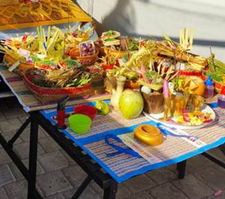
|
Figure 1 Banten Photo |
2.3. Google My Maps
Google is a company that started as a search engine and is now always growing to expand its services with more than 50 internet services and products such as Gmail, maps to software for smartphones and tablets. Google was founded by Larry Page and Sergey Brin while they were students at Stanford University. They both hold 16 percent of the company's shares. They made Google a private company on September 4, 1998. Google Maps is a web mapping service developed by Google. This service provides satellite imagery, street maps, 360° panoramas, traffic conditions and route planning for traveling by foot or car. Google Maps is a mainstay for quickly searching for locations related to daily needs, as well as for exploring many new places without having to ask a lot of people around you. Features include sharing those locations. Google Maps was introduced in February 2005 and was a revolution in how maps were displayed on the web, namely by allowing users to drag the map so they could navigate it Natalia (2020) .
2.4. Research Conceptual Model
Conceptually, this research model starts from initial research by conducting observations and distributing questionnaires online using Google forms to identify problems. If the problem has been identified, a solution is found, namely the creation of a digital map, followed by testing the resulting application.
Figure 2
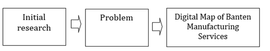
|
Figure 2 Research
Conceptual Model |
3. RESULTS AND DISCUSSIONS
3.1. Initial Research
The initial research carried out was by distributing questionnaires online using Google Form to the general public at random with a total of 10 respondents with the aim of strengthening problem identification in addition to making observations. The questions raised were about knowledge about offerings as a ceremonial means, people's skills in making offerings, types of offerings for ceremonies, levels of offerings for ceremonies, forms of offerings for ceremonies, difficulties in making offerings yourself because there is no time or other difficulties, buying offerings for the ceremony you need services for making offerings for the ceremony, regarding the location of offerings making services in Denpasar City and finding locations for offerings making services in Denpasar City. The questionnaire complete with questions is in attachment 1 and the google form link: https://forms.gle/c5pYPdDaefv1ioSK7, the table for processing questionnaire data is in Table 1.
Table 1
|
Table 1 Data Processing Results |
|||||||||||||
|
Respoundden |
Question |
Total |
% |
Category |
|||||||||
|
|
1 |
2 |
3 |
4 |
5 |
6 |
7 |
8 |
9 |
10 |
|
|
|
|
1 |
0 |
0 |
0 |
0 |
1 |
1 |
1 |
1 |
1 |
1 |
6 |
60 |
high |
|
2 |
1 |
0 |
0 |
0 |
1 |
1 |
1 |
1 |
1 |
1 |
7 |
70 |
high |
|
3 |
1 |
0 |
0 |
1 |
1 |
1 |
1 |
1 |
1 |
1 |
8 |
80 |
high |
|
4 |
1 |
0 |
0 |
0 |
1 |
1 |
1 |
1 |
0 |
1 |
6 |
60 |
high |
|
5 |
1 |
0 |
1 |
1 |
1 |
1 |
1 |
1 |
1 |
1 |
9 |
90 |
high |
|
6 |
1 |
0 |
1 |
1 |
1 |
1 |
1 |
1 |
1 |
1 |
9 |
90 |
high |
|
7 |
1 |
0 |
1 |
1 |
1 |
1 |
1 |
1 |
1 |
1 |
9 |
90 |
high |
|
8 |
0 |
0 |
0 |
0 |
1 |
1 |
0 |
0 |
0 |
0 |
2 |
20 |
low |
|
9 |
1 |
0 |
1 |
0 |
1 |
1 |
1 |
1 |
0 |
1 |
7 |
70 |
high |
|
10 |
1 |
1 |
1 |
1 |
1 |
1 |
1 |
1 |
1 |
1 |
10 |
100 |
high |
Minimum score: 0
Maximum score: 10
Maximum-minimum = 10-0 =10
Intervals: 10/2 = 5
P=(∑x)/(∑y) x 100 %
Information:
P: Percentage of Eligibility
∑x: Total Number of Respondents' Answers
∑y: Maximum Score
Guttman Scale
There are only 2 answers to questions in the questionnaire, namely the answer "Yes" has a value of 1 and the answer "No" has a value of 0. The following is a table of categories based on the results of data processing.
Table 2
|
Table 2 Category of Data Processing Results |
||||
|
Category |
Value |
Percentage
Interval |
Frequency |
Frequency
percentage |
|
High |
6-10 |
51%-100% |
9 |
90 % |
|
Low |
0-5 |
0%-50% |
1 |
10 % |
Based on the results of data processing from random Denpasar city residents, it is stated that the need for a Geographic Information System application is very important to be built with a percentage of 90% in the high category, this is influenced by several factors such as time, lack of skills in making your own offerings, the level of complexity of the offerings and other factors.
3.2. Digital Map of Banten Making Services
The spatial data displayed on Google Maps, precisely in Figure 3, is spatial data for mapping banten making services in 4 sub-districts in the city of Denpasar.
Figure 3
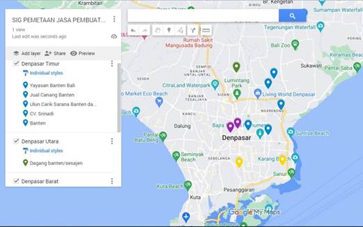
|
Figure
3 Results of Digital Map Digitization |
In Figure 4, there is an integration between spatial data, namely
spatial coordinate data for the city of East Denpasar as one of the
sub-districts in the city of Denpasar, which is integrated with non-spatial
data in the form of banten attributes which are columns in the table, such as
the attributes name of the banten service, address, contact person, package.
banten, price and sub-district area
Figure
4
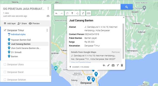
|
Figure
4 Integration of Spatial Data and
Non-Spatial Data |
4. CONCLUSIONS and RECOMMENDATIONS
Geographic Information System (GIS) mapping is a system designed to collect, store, analyze and display geographic data. GIS integrates various types of data to produce maps and location-based information that is useful in a variety of applications Supuwiningsih et al. (2020). A Geographic Information System for mapping the production of banten services in the city of Denpasar has been built which can answer the problems faced by the Hindu community in that city who have difficulty getting information about the location of the sale of banten.
CONFLICT OF INTERESTS
None.
ACKNOWLEDGMENTS
This research has been supported by ITB STIKOM Bali: encompass the Chairman along with its management team, providing its support and resources. Hope the result of this work can be useful for world community.
REFERENCES
Adhikang, L. (2019). Sarathi Banten Di Bali Antara Profesi Dan Yadnya Dalam Perspektif
Persaingan Pasar Bebas. Jurnal Pangkaja Program Pascasarjana Institut Hindu,
77-86.
Arini. (2017). Kontemplasi: Tata Susila Pembuatan Sarana Upacara (Banten) Pada
Kehidupan Masyarakat Bali. Jurnal Prodi Teologi Hindu STAHN Mpu Kuturan
Singaraja, 124-132.
Bunch, Kumaran, & Joseph. (2012). Using Geographic Information System (GIS) for Spatial Planning and
Environment Management in India. International Journal of Applied Science and
Technology, 40-54.
Dewi. (2020). Upacara & Upakara Hindu: Peranan Tour Guide Dalam Pengembangan
Pariwisata Spiritual Di Bali. Cultoure, 1-9.
Dharmawan, I. G. (2020). Bhakti Marga Yoga: Implementasi Dalam Kehidupan Pribadi Dan Sosial. Jurnal Pendidikan Agama Dan Budaya Hindu, 70-87.
Mariyatni, N. P. S., Juniariani, N. M. R., & Pratama, A. D. Y. (2021). Pendampingan Pencatatan Keuangan dan Pemasaran Sarathi Banten. International Journal of Community Service Learning, 5(2), 162–168. https://doi.org/10.23887/ijcsl.v5i2.35069
Natalia, W. D. (2020). Sistem Informasi Geografis Pemetaan Tempat Kos di Samarinda Berbasis Web. Buletin Poltanesa. 11-17. https://doi.org/10.51967/tanesa.v21i1.320
Prahasta. (2014). Sistem Informasi Geografis: Aplikasi Pemrograman MapInfo. Bandung: Bandung: Informatika.
Supuwiningsih, N. N., PaulaDewanti, KadekSukerti, N., & Putra, I. M. A. (2020). Forecasting of Agricultural Production Results in South Denpasar Using Quadratic Trend Method Based GIS, International Journal of Engineering Technologies and Management Research, 5(2). https://doi.org/10.29121/ijetmr.v5.i2.2018.160
Wahyuni, N. M. (2017). Nilai-Nilai Pendidikan Agama Hindu Pada Banten Pemahayu Angga Sarira Di Desa Mendoyo Dangin Tukad Kecamatan Mendoyo Kabupaten Jembrana. Jurnal Penelitian Agama Hindu, 354. https://doi.org/10.25078/jpah.v1i2.265
|
|
 This work is licensed under a: Creative Commons Attribution 4.0 International License
© IJETMR 2014-2024. All Rights Reserved.