
|
|
|
|
DEVELOPMENT E-MODUL GEOGRAPHIC INFORMATION SYSTEM BASED ON MOODLE
Ni Nyoman Supuwiningsih
1![]()
![]() ,
I Made Pandu Putra Riadi 2
,
I Made Pandu Putra Riadi 2![]() , Ni Putu Winten
Sari Cahyaningrum 2
, Ni Putu Winten
Sari Cahyaningrum 2![]()
1 Computer
System, ITB STIKOM Bali, Indonesia
2 Information
System, ITB STIKOM Bali, Indonesia
|
|
|
ABSTRACT |
|
|
The
development of information technology has affected all fields, namely the
field of education without exception. Information technology-based learning
(e-learning) is learning where all information is centered on students. If
the educator is not present, learning can still be done with e-learning
learning which can be accessed using the internet. Current learning at ITB
STIKOM Bali, especially in the Information Systems course, is still not
effective due to limited learning resources that can increase student
enthusiasm for learning. This lack of learning resources for students is a
problem during a pandemic and currently facing the digital era due to
unpreparedness in dealing with the digital world, this also occurs at the ITB
STIKOM Bali campus which still uses learning resources that are less
attractive and less interactive which causes students to be less interested
to learn. This is supported by data from questionnaire results from 60
students who have completed GIS lectures with previous learning resources,
around 72% of students stated that they agreed with the development of
learning resources using multimedia e-modules. This course was chosen in the
development of teaching materials because teaching Geographic Information
Systems requires high-level thinking skills in the process of understanding
theory and its applications, therefore higher-order thinking skills play an
important role in developing understanding of the material and learning along
with it. requires high concentration in digital map digitization. Based on
these problems, it is necessary to develop learning resources in the form of
Moodle-based multimedia-based e-modules that can be accessed by students
online. The method of making an application using the method. The research
method consists of literature study, MDLC (Multimedia Development Life Cycle)
stages and evaluation. Testing the e-module by giving questionnaires to
students taking Geographic Information Systems courses. The software used in
making e-modules is Adobe Captivate and other supporting software in photo,
audio, and video editing. Testing the effectiveness of the e-module by giving
pre-test and post-test to 20 students randomly with an average N-Gain
learning result of 0.78 in the high category so the e-module is very effectively
used as a learning resource. |
|||
|
Received 19 June 2023 Accepted 20 July 2023 Published 09 August 2023 Corresponding Author Ni Nyoman
Supuwiningsih, ninyomansupuwiningsih@gmail.com DOI 10.29121/ijetmr.v10.i8.2023.1348 Funding: This research
received no specific grant from any funding agency in the public, commercial,
or not-for-profit sectors. Copyright: © 2023 The
Author(s). This work is licensed under a Creative Commons
Attribution 4.0 International License. With the
license CC-BY, authors retain the copyright, allowing anyone to download,
reuse, re-print, modify, distribute, and/or copy their contribution. The work
must be properly attributed to its author.
|
|||
|
Keywords: E-Modul,
Multimedia, Geographic Information System, MDLC (Multimedia Development Life
Cycle |
|||


1. INTRODUCTION
The development
of Information Technology from time to time is always changing. Almost all
areas of life in society use information technology without exception in the
field of education. The educational paradigm has changed due to the development
of information technology from conventional learning processes or Teacher
Centered Learning (TCL) to information technology-based learning where students
become learning centers or known as Student Centered Learning (SCL).
This Student Centered Learning (SCL) based approach allows
students to develop their creativity without limits, and students can utilize
teaching materials, media or technology to acquire knowledge and students can
determine their own learning style in seeking or acquiring knowledge. The
implementation of Student Centered Learning (SCL)
learning which involves student activity based on technology as a technological
development that cannot be denied anymore, interesting online learning resource
facilities are still needed because towards independent learning in the face of
the digital era of the industrial revolution 4.0, adequate electronic learning
resources are needed. The emergence of changes and shifts in learning paradigms
has an impact on various aspects of learning, including in instructional design
and media development which need to be integrated with technological
developments Nita & Ali (2020).
This lack of
learning resources for students is a problem during a pandemic and currently
facing the digital era due to unpreparedness in dealing with the digital world,
this also occurs at the ITB STIKOM Bali campus which still uses learning
resources that are less attractive and less interactive which causes students
to be less interested to learn. This is also supported by data from
distributing questionnaires to 60 students who have taken Geographic Information
Systems courses or have completed GIS courses with previous learning resources,
namely Microsoft power point, the questionnaire results data are in Appendix 2.
Questionnaires with the Guttman scale are distributed online using google form
with the result being that the high category frequency is 43 meaning that out
of 60 students only 43 people around 72% agree with the development of
multimedia-based e-modules for Geographic Information Systems courses. The
frequency of the low category was 17 students, around 28%, meaning that as many
as 17 students did not agree that the previous learning resources were
developed into multimedia-based e-modules. Based on the comparison of the
results of data processing, it can be concluded that it is very necessary to
have multimedia e-modules for the development of learning resources beforehand,
seen from the number of students in the high category more than the data of
students who do not agree with the development of multimedia-based e-modules
for the Systems course. Geographic Information. Teaching Geographic Information
Systems requires high-level thinking skills in the process of understanding the
theory and its application, therefore higher-order thinking skills (Higher
Order Thinking Skills) play an important role in developing understanding of
the material and learning Thamrin & Widodo (2019). Development of understanding of the
material can be done by selecting the appropriate learning model and method in
the learning process. The selection aims to make student learning active, interactive,
and creative in the learning process Mutmainnah et al. (2021). Choosing the right learning method is a
manifestation of the creativity of a teacher so that students are not bored or
bored in receiving courses, especially Geographic Information Systems because
it requires high concentration in the process of digitizing digital maps and
understanding the concepts.
Multimedia-based
e-modules as teaching materials or learning resources that are more practical
in their operations to support GIS learning. The goal is for students to
understand and apply it more quickly. Books with too many descriptions and too
long tutorials in operating GIS tools actually confuse
students. Learning outcomes are influenced by various factors, including
interest and motivation to learn, learning media, learning strategies, learning
methods. One of the difficulties in understanding abstract material can be
overcome with learning media Mutmainnah et al. (2021). Based on these problems, this research
provides solutions in making teaching materials or learning resources for
Geographic Information Systems courses packaged in the form of interactive
learning multimedia e-modules that can be accessed online by students via moodle on the e-learning website of the ITB STIKOM Bali
campus. E-Module in delivering content through text, audio, video, animation
and so on so that learning is expected to be fun and easy to understand. The
software used in making e-modules is Adobe Captivate and other supporting
software in photo, audio, and video editing. The research method consists of
literature study, MDLC (Multimedia Development Life Cycle) stages and
evaluation.
According to
the research results of Nita Sunarya Herawati and Ali
Muhtadi that the application of the use of e-modules in general can be carried
out in a feasible category and gets positive responses from students and there
are differences in learning outcomes between the results of the pretest before
using the e-module and the post test after using the
e-module. After testing with several experts that the e-module is suitable for
use as a learning medium Nita & Ali (2018)
2. MATERIALS AND METHODS
2.1. E-Module Concept
E-Module is a
form of module that is packaged digitally and interactively because the
material can be presented in the form of pdf files, audio, video, animation and
so on which can make students learn actively and independently. E-module is an
electronic version of the module where access and use is
carried out through electronic devices such as computers, laptops, tablets or
even smartphones. E-modules are a set of digital or non-printed teaching
materials that are systematically arranged to be used for independent learning
purposes so that it requires students to learn to solve problems in their own
way. E-modules can make learning activities more interactive because in the
presentation they can be inserted in the form of animations, images, videos,
and audio Masruroh & Agustina (2021). E-Modules will also be useful in
increasing the effectiveness of online teaching and learning activities because
they can be accessed at any time. Electronic modules or e-modules are modules
in digital form, consisting of text, images, or both which contain material
inside accompanied by simulations that can and are appropriate for learning Herawati (2018).
The developed
e-module must have the necessary characteristics in order to
be able to produce modules that are able to increase the motivation of its
users Fajarini (2018). The characteristics of the e-module
being developed are self-instruction, self-contained, stand-alone, adaptive,
and user-friendly.
2.2. Geographic Information System
Geographic
Information Systems is one of the courses in the curriculum in the Information
Systems major at the ITB STIKOM Bali campus. Geographic Information System
(GIS) or Geographic Information System (GIS) is a combination of the three main
elements, namely system, information, and geography. Geographic Information
System is a collection of components that interact with one another in order to collect data, process data, store and produce
information to support decision-making, control, and provide an overview of the
activities carried out within the company. Supuwiningsih & Muhammad Rusli (2020). The concept of information is the result
of data processing and geography is the study of the earth's surface. The
concept of a geographic information system is a collection of components that
interact with each other in data processing to produce geographic information
whose implementation is in the form of digital maps. Geographic information
system can also be defined as an information system that can analyze, store,
update, integrate and display all forms of information related to the earth's
surface.
2.3. Learning Multimedia
The multimedia concept put forward by Vaughan in 2006 is
multimedia consisting of text elements, images/photos, graphic art, sound, animation,
and video elements that are digitally manipulated Rusli et al. (2017). Learning
multimedia can be interpreted as a multimedia application that is used in the
learning process, channeling knowledge, skills, and attitudes and can stimulate
the thoughts, feelings, attention and willingness of
those who learn so that the learning process occurs intentionally according to
the learning objectives. In general, the benefits that can be obtained from
multimedia learning are that the learning process is more interesting, more
interactive, the amount of teaching time can be reduced, the quality of
learning can be improved, and the teaching and learning process can be carried
out anywhere and anytime, and students' learning attitudes can be improved.
2.4. Moodle
The LMS (Learning Management System) used in
this study, to be accessible to e-modules by students, is Moodle. Moodle
(Modular Object Oriented Dynamic Learning Environment)
is a website-based CMS (Content Management System) application that can change
face-to-face learning media into online face-to-face learning or what is called
e-learning. Moodle is the most popular open source
program among existing e-learning programs. This Moodle application was first
developed by Martin Dougiamas in August 2002 with
Moodle version 1.0. The use of the Moodle application is very helpful,
especially in the midst of the Covid-19 pandemic
situation which requires social distancing, so this Moodle application can be
used as a solution so that teaching and learning activities continue as they
should. LMS is a set of web-based systems used by teachers/lecturers/and/or
students to share material, send and complete assignments and communicate
online Astriani & Ismah (2021). The advantage of using LMS in learning during a pandemic is that
students' learning time becomes flexible because it can be accessed at any time
via electronic devices such as their laptops or gadgets Wiragunawan (2020).
2.5. Metode
MDLC (Multimedia Development Life Cycle) is a system
development method that is suitable for developing multimedia-based systems Riyanto and Singh (2015). Multimedia Development
Life Cycle consists of six stages, namely Kumala et al. (2020)
1)
Concepts
The stage to determine the purpose and who are the users
of the program. The concept stage is the stage for determining the purpose and
to whom multimedia is addressed (audience identification). In addition, it
determines the type of application (presentation, interactive, etc.) and the
purpose of the application (entertainment, learning, etc.). Basic rules for
design are also determined at this stage e.g., size, target. The output of this
stage is usually in the form of a narrative document to express the project
objectives to be achieved.
2)
Design
The stage of making specifications regarding product
architecture, style, appearance, and material requirements for the product.
Design (design) is the stage of making specifications including product
architecture, style, appearance and material requirements or materials for the
program. Specifications are made as detailed as possible so that in the next
stage, namely collecting and assembling materials, new decision-making is no
longer needed, it is enough to use storyboards to draws a description of each
scene by listing all multimedia objects.
3)
Material Collecting
The stage of collecting materials according to the needs
of the work done. Material collection is the stage of collecting materials
according to the needs being worked on. These materials include clip-art, graphics, animation, video, audio. This stage can
be carried out in parallel with the assembly stage, but it is also possible
that the material collecting stage and the assembly stage will be carried out
in a linear and non-parallel manner.
4)
Assembly
Manufacturing Stage. The assembly stage is the stage of
making all objects or multimedia materials made. Project creation is based on
the design stage, such as a storyboard, flowchart, or navigational structure.
5)
Testing
Testing Stage. This stage is carried out after the
completion of the assembly stage by running the product whether there is an
error or not. This stage is referred to as the alpha testing stage (alpha test)
where testing is carried out by the manufacturer. The function of this stage is
to see whether the results of making the project are as expected or not, then a
test table will be made to test the product criteria Irawan et al. (2015).
6)
Distributions
The product will be stored in a storage medium. At this
stage the product will be stored in a storage medium. If the storage media is
not sufficient to accommodate the product, compression of the product will be
carried out. This stage can also be referred to as the evaluation stage for the
development of finished products so that they become better. The results of
this evaluation can be used as input for the concept stage of the next product.
Figure 1
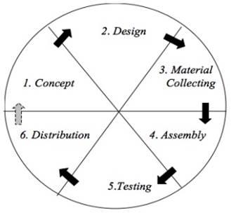
|
Figure 1 MDLC (Multimedia Development Life Cycle) |
3. RESULTS AND DISCUSSIONS
Review previous sources by
providing a
number of online
questionnaire questions to 60 students who had previously taken Information
Systems courses with answer choices using the Guttman scale. The Guttman scale
only has 2 answers to the questions in the questionnaire, namely the answer
"Yes" has a value of 1 and the answer "No" has a value of
0. The following is a table of categories based on the results of data
processing.
Table 1
|
Table 1 Value Category |
||||
|
Category |
Value |
Percentage Intervals |
Frequency |
Frequency percentage |
|
High |
6-10 |
51%-100% |
43 |
72% |
|
Low |
0-5 |
0%-50% |
17 |
28% |
Based on the
results of data acquisition through questionnaires from 60 students who took the
Geographic Information Systems course, it can be concluded that there were 2
identified categories, namely high and low. The frequency of the high category
is 43, meaning that out of 60 people, only 43 people, around 72%, with a total
value of answers regarding previous learning resources that were less
interesting and hoped that previous learning resources could be replaced by
using multimedia-based e-modules or agreed to the development of
multimedia-based e-modules for subjects. Geographic Information Systems course.
The frequency of the low category was 17 students, around 28%, meaning that as
many as 17 students did not agree that the previous learning resources were
replaced by multimedia-based e-modules. Based on the comparison of the results
of data processing, it can be concluded that it is very necessary to have
multimedia e-modules for the development of learning resources beforehand, seen
from the number of students in the high category more than the data of students
who do not agree with the development of multimedia-based e-modules for the
Systems course. Geographic Information.
3.1. E-module Development Results
1)
Concept Stage
This stage is
the initial stage of developing the e-module for the Geographic Information
System (GIS) course, which is to determine the purpose of the e-module being
built and determine the users of this e-module. The purpose of this e-module is
to provide knowledge about the concept of Geographic Information Systems
through learning resources in the form of multimedia e-modules that are more
interesting and effective because they can be accessed online via Moodle as a
form of LMS (Learning Management System).
2)
Design Stage (Design)
This stage is
the second stage in the MDLC stage, which is the stage in making the Geographic
Information System e-module storyboard. Storyboard Meetings 1 and 2 discussed
the geographic introductory sub-material

|
Figure 2 Storyboard Meetings 1 and 2 |
The storyboards
for Meetings 3 and 4 discussed the sub-matter of coordinate systems and map
projections which can be seen in Figure 3.
Figure
3

|
Figure
3 Storyboard
Meetings 3 and 4 |
3)
Material Collection
This stage is
the stage of gathering materials such as the content contained in the e-module
which is adjusted to the SRP (Semester Learning Plan), the software used is
Adobe Captivate, and the use of Ocen audio software for audio editing, the use
of Adobe Photoshop images and software for video editing.
This stage is
the stage of gathering materials such as the content contained in the e-module
which is adjusted to the SRP (Semester Learning Plan), the software used is
Adobe Captivate, and the use of Ocenaudio software
for audio editing, the use of Adobe Photoshop images and software for video
editing.
Meetings 1 and
2: Geographical introduction
Meetings 3 and
4: Coordinate system and map projection
Meetings 5 and
6: Processing of spatial data and attribute data
Meeting 7:
Raster and vector data
Meeting 8: Data
Visualization and Presentation in GIS
Meeting 9:
Making spatial data and attributes
Meeting 10:
Basic GIS (spatial and attribute analysis) operations
Meeting 11: GIS
operation (spatial and attribute analysis) continued
Meeting 12:
Raster data analysis
Meeting 13:
Internet-based GIS
Meeting 14: GIS
Implementation
4)
Assembly
This stage is
the stage of making the Information Systems course e-module according to the
design in the form of a storyboard, combining content with audio, video, and
animation narration. This e-module was developed using Adobe Captivate
software. Meetings 1 and 2: the first appearance of the e-module for Geographic
Information Systems courses which discuss geographical introductory sub-materials
Figure 4

|
Figure 4 Initial View of the E-Module Meetings 1 and 2 |
Meetings 3 and
4: the first display of the e-module for the Geographic Information System
course which discusses the sub-material of coordinate systems and map
projections.
Figure 5
|
Figure 5 Initial View of the E-Module Meetings 3 and 4 |
5)
Testing phase
This stage is
the testing stage of the Geographic Information System e-module that was built,
the test is carried out by the e-module developer (alpha test) and the second
test by the user (beta test) by giving questionnaires to students as e-module
users.
6)
Distribution (Distribution)
At this stage,
the e-module is stored by distributing it to students via the Moodle LMS that
has been provided by the ITB STIKOM Bali campus, so that it can be accessed by
students.
Meetings 1 and
2: E-Modules uploaded into the ITB STIKOM Bali E-Learning Moodle which discuss
geographic introductory sub-materials
Figure 6

|
Figure 6 Combined E-Module with Moodle |
3.2. Student Learning Outcomes
By randomly assigning pre-test and post-tests to 20 students, the newly
built e-module will be evaluated in terms of how well it aids students enrolled
in Geographic Information Systems courses in their learning process. The
results are as follows in Table 1.
Table 2
|
Table 2 Learning
Outcomes |
|||
|
Respondent |
Pre-Test |
Post-Test |
N-Gain |
|
1 |
90 |
100 |
1 |
|
2 |
95 |
100 |
1 |
|
3 |
80 |
100 |
1 |
|
4 |
85 |
100 |
1 |
|
5 |
80 |
90 |
0.5 |
|
6 |
90 |
100 |
1 |
|
7 |
90 |
100 |
1 |
|
8 |
70 |
100 |
1 |
|
9 |
80 |
90 |
0.5 |
|
10 |
80 |
90 |
0.5 |
|
11 |
90 |
100 |
1 |
|
12 |
95 |
100 |
1 |
|
13 |
90 |
95 |
0.5 |
|
14 |
80 |
90 |
0.5 |
|
15 |
85 |
95 |
0.67 |
|
16 |
80 |
90 |
0.5 |
|
17 |
90 |
100 |
1 |
|
18 |
90 |
100 |
1 |
|
19 |
60 |
80 |
0.5 |
|
20 |
80 |
90 |
0.5 |
|
Rata-rata |
84 |
95.5 |
0.78 |
N-Gain Formula Meltzer (2002)
![]()
According to the category table, the N-Gain learning
outcomes of 20 randomly selected students are, on average, 0.78, and because
0.78 > 0.7, the value is classified as high. Consequently, using e-modules
as student teaching resources can be a useful way to enhance learning.
4. CONCLUSIONS AND RECOMMENDATIONS
This research has produced an e-module for the course Geographic Information Systems which can be accessed by students through the LMS in the form of Moodle. This e-module is based on multimedia, namely e-modules packaged using animation, text, audio, and video with the aim of attracting students' interest in learning in an asynchronous form. The development of this e-module uses the MDLC (Multimedia Development Life Cycle) method which consists of the concept stage, design stage, material collection stage, e-module creation stage, testing stage and distribution stage. This e-module can be accessed online through Moodle so that it can help students study effectively according to their wishes in learning because this e-module is interactive. Lecturers can also make it easier to provide material that has been replaced with e-modules so that the role of the lecturer changes to that of a facilitator. Testing the effectiveness of the e-module by giving pre-test and post-test to 20 students randomly with an average N-Gain learning result of 0.78 in the high category so the e-module is very effectively used as a learning resource.
CONFLICT OF INTERESTS
None.
ACKNOWLEDGMENTS
This research has been supported by ITB STIKOM Bali: encompass the Chairman along with its management team, providing its support and resources. Hope the result of this work can be useful for world community.
REFERENCES
Ajun, P., Paiman, & Agus, S. (2021). Pengembangan Bahan Ajar Sistem Informasi Geografis Berbasis HIGHER ORDER TINKING SKILL (HOTS). Geodika: Jurnal Kajian Ilmu dan Pendidikan Geografi, 43-52. https://doi.org/10.29408/geodika.v5i1.3194.
Astriani, L., & Ismah. (2021). Pembelajaran Jarak jauh Menggunakan Learning Management System di Masa Pandemi COVID -19. Holistika : Jurnal Ilmiah PGSD, 54-60. https://doi.org/10.24853/holistika.5.1.54-60.
Fajarini, A. (2018). Membongkar Rahasia Pengembangan Bahan Ajar IPS. Jember : Gema Press.
Herawati, D. (2018). Pengembangan Modul Elektronik (E-Modul) Interaktif pada Mata Pelajaran Kimia Kelas XI SMA. Jurnal Inovasi Teknologi Pendidikan, 180-191. https://doi.org/10.21831/jitp.v5i2.15424.
Irawan, A., Laurin, M.S., and Suherman. (2015). Perancangan Animasi Pembelajaran Perawatan Mesin. Jurnal Prosisko, 2(1), 1-9.
Kumala, F. N., Ghufron, A., Astuti, P. P., Crismonika, M., Hudha, M. N., and Nita, C. I. R. (2020). MDLC Model for Developing Multimedia E-Learning on Energy Concept for Primary School Students. Journal of Physics, 1-7. https://doi.org/10.1088/1742-6596/1869/1/012068.
Masruroh, D., & Agustina, Y. (2021). E-Modul Berbasis Android Sebagai Pendukung Pembelajaran Daring Dalam Upaya untuk Meningkatkan Hasil Belajar Peserta Didik. Jurnal Ekonomi, Bisnis dan Pendidikan, 559-568. https://doi.org/10.17977/um066v1i62021p559-568.
Meltzer, D. (2002). The Relationship Between Mathematics Preparation and Conceptual Learning Gain in Physics. American Journal of Physics, 1259-1268. https://doi.org/10.1119/1.1514215.
Mutmainnah, Aunurrahman, Warneri (2021). Efektivitas Penggunaan E-Modul Terhadap Hasil Belajar Kognitif pada Materi Sistem Pencernaan Manusia di Madrasah Tsanawiyah. Jurnal BASICEDU, 1625-1631. https://doi.org/10.31004/basicedu.v5i3.952.
Nita, S.H., & Ali, M. (2018). Pengembangan Modul Elektronik (E-Modul) Interaktif Pada Mata Pelajaran Kimia Kelas XI SMA. Jurnal Inovasi Teknologi dan Pendidikan, 180-191. https://doi.org/10.21831/jitp.v5i2.15424.
Nita, S.H., & Ali, M. (2020). Pengembangan Modul Elektronik (E-Modul) Interaktif pada Mata Pelajaran Kimia Kelas XI IPA SMA. Jurnal At-Tadbir STAI Darul Kamal NW Kembang Kerang, 57-69. http://dx.doi.org/10.21831/jitp.v5i2.15424.
Rusli, M., Hermawan, D., Supuwiningsih, N. N., STIKOM Bali (2017). Multimedia Pembelajaran yang Inovatif. Yogyakarta : Andi.
Supuwiningsih, N. N., Muhammad Rusli, M.T (2020). Sistem Informasi Geografis : Konsep Dasar dan Implementasi. Yogyakarta : Andi.
Thamrin, N.R., & Widodo, P. (2019). Developing Higher Order Thinking Skills (HOTS) for Reading Comprehension Enhancement. Journal of Physics, 1-6. https://doi.org/10.1088/1742-6596/1179/1/012073.
Wiragunawan, I. G. (2020). Pemanfaatan Learning Management System (LMS) dalam Pengelolaan Pembelajaran Daring pada Satuan Pendidikan. EDUTECH : Jurnal Inovasi Pendidikan Berbantuan Teknologi, 82-89. https://doi.org/10.51878/edutech.v2i1.981.
|
|
 This work is licensed under a: Creative Commons Attribution 4.0 International License
© IJETMR 2014-2023. All Rights Reserved.