ShodhKosh: Journal of Visual and Performing ArtsISSN (Online): 2582-7472
|
|
ENHANCING THE PERCEPTION OF AN URBAN AREA - A CASE STUDY OF BATALA CITY
Nishant Arora 1![]()
![]() ,
Utkarsh Kumar 2
,
Utkarsh Kumar 2![]()
![]()
1 Assistant
Professor, K R Mangalam
University, Gurgaon, Haryana, India
2 PG
Student, Guru Nanak Dev University, Amritsar, Punjab, India
|
|
|
ABSTRACT |
|
|
The city image
defines how people see and recall aspects in urban environments. The most
distinguishing components of urban landscape, classified as pathways, nodes,
boundaries, districts, and landmarks, form people's mental representations of
the city. Because to urbanisation, India's historic
cities are in grave danger. The heritage zones are essential components of
the city's fabric, contributing to the city's image. Apart from possessing
magnificent examples of traditional architecture, these heritage neighbourhoods serve as cultural and social hubs for the
city, providing citizens with a sense of worth. The development process over
the last few decades has had such an impact on historic towns that evidence
of their historic worth is being destroyed forever. This historical zone is
plagued by numerous concerns and problems. People come to Batala to enjoy the
city's Punjabi culture and traditions. Maximum tourist visit
to the city during "BABE DA VIVAH". This cultural zone is a
one-of-a-kind place where the ambiance blends both old and modern
architecture, and it is a multifunctional area offering a mix of history,
educational, entertainment, residential, culinary, and so on. This area has a
rich history, as evidenced by the presence of four major ancient monuments:
Shamsher Khan Tomb, Jal Mahal, Baring Chaple, and Maharaj Sher Singh Palace.
During the British Raj, this region was also frequented by British people.
This cultural district has a number of issues, including a lack of a
pedestrian area, criminal activity, a change in space use, changes in scale
and land use, and so on. Furthermore, Batala city has no space for social
interaction or recreation; there is only 0.81% of recreational area in the
city, which is almost negligible; thus, there is an urgent need to create one
cultural district in the city, which will not only help the city's residents socialise but will also attract tourists, resulting in
the preservation of heritage monuments and increased revenue for the city. |
|||
|
Received 29 August 2023 Accepted 09 December 2023 Published 14 December 2023 Corresponding Author Nishant
Arora, nishantarora.11@gmail.com DOI 10.29121/shodhkosh.v4.i2
ECVPAMIAP.2023.704 Funding: This research
received no specific grant from any funding agency in the public, commercial,
or not-for-profit sectors. Copyright: © 2023 The
Author(s). This work is licensed under a Creative Commons
Attribution 4.0 International License. With the
license CC-BY, authors retain the copyright, allowing anyone to download,
reuse, re-print, modify, distribute, and/or copy their contribution. The work
must be properly attributed to its author.
|
|||
|
Keywords: Historic Town, City Image, Heritage Neighbourhood, Cultural District |
|||


1. INTRODUCTION
Because to urbanisation, India's historic cities are in grave danger. The heritage zones are essential components of the city's fabric, contributing to the city's image. Apart from possessing magnificent examples of traditional architecture, these heritage neighbourhoods serve as cultural and social hubs for the city, providing citizens with a sense of worth. The development process over the last few decades has had such an impact on historic towns that evidence of their historic worth is being destroyed forever. Demographic change, massive movement from rural to urban regions, De Chiara & Koppelman (1975). The introduction of motor vehicles, flourishing commerce leading to the transition of residential neighbourhoods into commercial ones, and so on. The original character of heritage sites has altered, and cities have become more congested, leaving no recreational space for people to enjoy or socialise.
Batala holds significant religious importance for adherents of the Sikh faith. Guru Nanak Dev Ji, the esteemed progenitor of the Sikh faith, entered into matrimony with Sulakhni, the daughter of MulChand Chauna, at this location. Temples and Gurdwaras linked to the matrimonial events of the Guru attract people from many parts of the globe. Annually. During the commemoration of Guru Nanak's matrimonial union, commonly referred to as "babe da vivah," several festivities are organised. Additionally, there exists a historical Gurdwara Satkartarian Sahib that is linked to Sri Har Gobind ji, the sixth Guru of the Sikh community. Batala was historically recognised as the prominent industrial hub in Asia due to its significant production of C.I. agricultural and mechanical machinery, as well as casting. Batala continues to have significant prominence in northern India as a prominent hub for the manufacturing of C.I Casting and mechanical gear. Additionally, it functions as a centre for agricultural trade and an important centre for industrial activities. Additional sectors that are represented within the industry include cotton ginning, weaving, sugar refining, and rice milling. Batala is an intriguing urban centre because to its classification as a Tehsil, which distinguishes it from its encompassing district of Gurdaspur by virtue of its comparatively higher level of development. The present-day area of India's Punjab is separated into three natural regions: the Majha, the Doaba, and the Malwa. Batala, along with Amritsar, Gurdaspur, and Pathonkot, is located in the Majha area. Batala, a British India town in the Gurdaspur district of Punjab, is 24 kilometres away and has a station on a branch of the north-western railway. Amritsar has a population of around 2 lakh people. It is a significant commerce centre, with manufacturers of spare parts required for machinery manufacturing. There are many cast iron foundries in this city, and metal-flux is a well-known facility for producing foundry flux. It is also known as "Punjab's Birmingham." Batala is an old, historical, and culturally significant city in India. According to the Census of India 2011, the city in question is ranked as the eighth biggest in the state of Punjab, with a population of 158,404 individuals. Situated at an elevation of 240 metres above mean sea level, it has a notable geographical position. Batala is considered the second-oldest city in chronological order, behind Bathinda. Batala was formerly recognised as the "iron bird of Asia" due to its significant production of C.I casting. Batala has an approximate age that is 109 years greater than that of Amritsar. The city is constructed entirely within a fortified structure, with twelve gates that serve as points of entry and facilitate the inhabitants' sustenance and security. Only 5 gates are physically present, but their condition is deplorable. According to Whittick (1974), the city has various urban design features of built structure, including as heritage sites, religious structures, and schools. Also included are natural sites like as Kasoor Nallah, which was historically used for domestic purposes. The archaeology department has designated only three heritage sites: Hazira Park, Jal Mahal, and Maharaja Sher Singh's residence. However, there are many unknown heritage sites in Batala's walled city that have historical significance and must be preserved. In Batala, there are no heritage restrictions or policies. To save Batala's heritage sites from deteriorating further, we must take necessary measures to preserve them. As a result, evolving heritage policies for protection and conservation are required., Divya. (2004). Every day, 10000-13600 guests come to Batala for various reasons. The city attracts the most visitors during the "babe da vivah" festival, which takes place in September. When compared to other cities in Punjab, tourism is not even considered a leading and essential economic activity in Batala, but the city has prioritised tourism and public services.
2. Literature Context
In his book "The Image of the City," Lynch (1960) claims that people regarded cities as made up of "elements" such as routes (along which mobility occurs) and boundaries (which distinguish one area of the urban fabric from another). Two case studies are chosen to better grasp the book's spirit of the city concepts: Bostan city and Jaipur walled city. Boston, for example, has separate districts as well as twisted, convoluted streets. The appeal of the city is enhanced by several elements, such as the expansive Boston Common, the State House adorned with its gilded dome, and the picturesque vista of the Charles River as observed from the Cambridge vicinity. Nicoll (1964). The prevailing sentiment among respondents was that the site is an antiquated, historically significant area characterised by dilapidated structures, yet with a few contemporary edifices interspersed amidst the aged ones. The small thoroughfares of the area experience congestion due to the high volume of pedestrians and vehicles, resulting in a lack of available parking spaces. However, notable disparities exist between the expansive main avenues and the more confined side streets. The central urban area is situated on a landmass that extends into a body of water. When discussing the periphery of Boston, a notable feature that captures attention is the transformation of the Charles River's shoreline. Formerly characterised as a marshy and neglected area, it has undergone significant delineation and urbanisation. The opposing coastal boundary, namely the port area, was also renowned and notable for its distinctive liveliness. Nonetheless, the perception of water was rather ambiguous due to its obstruction by numerous constructions and the cessation of former harbour activity.
Our understanding of the districts in Boston appeared to evolve as our familiarity with the city deepened. Individuals who possessed a high level of familiarity with the city of Boston demonstrated a strong recognition of its many regions, however placed significant reliance on minor features for the purpose of organisation and direction. Several individuals who possessed a deep understanding of Boston encountered difficulty in extrapolating specific observations into broader categories: while being aware of subtle differences across the city, they refrained from forming regional clusters of elements. Thematic continuities encompass the tangible characteristics that delineate several districts. The aforementioned elements encompass texture, spatial arrangement, physical structure, level of intricacy, symbolic representation, architectural typology, functional purpose, human engagement, inhabitants, level of upkeep, and geographical features. The concept of chowkris, or districts, within a walled city involves the partitioning of the city into smaller administrative units known as wards. These wards are further divided into sub-wards, utilising various sizes of grid. This division serves a purpose beyond facilitating movement and accessibility within the city. The centre plaza, known as Chowkri Sarhad, encompasses Govind Dev's Palace and the primary temple. It is encompassed by elevated walls and has a series of courtyards arranged in a sequential manner, with a network of entrances.
Scollay Square, the Charles Street roundabout, and South Station serve as notable intersection nodes within the city of Boston. The Charles Street roundabout and Scollay Square are significant intersection locations due to their positioning adjacent to Beacon Hill. Although the rotary may not possess inherent aesthetic appeal, it successfully symbolises the seamless connection between many elements such as the river, bridge, Storrow Drive, Charles Street, and Cambridge Street.
Landmarks can be designated as such by two distinct methods: firstly, by ensuring that the structure is visible from different vantage points, as shown by the John Hancock Building in Boston and the Richfield Oil Building in Los Angeles. Alternatively, landmarks can be produced by creating a noticeable contrast with neighbouring features, achieved through variations in setback and height. Located in Los Angeles, specifically at the intersection of 7th Street and Flower Street, stands an aged, two-story structure constructed from grey timber. This building, characterised by its unassuming nature, features a handful of modest retail establishments that are positioned around ten feet behind the building's frontage. The prominent architectural features of Jaipur city encompass the Najafgarh Fort and Surya Temple situated atop the hills that form the city's scenic backdrop. Additionally, the renowned Hawa Mahal, which has emerged as an emblematic symbol of the city, along with Jantar Mantar, Isar Lat, and the City Palace itself, contribute to the city's architectural grandeur. Furthermore, Jaipur boasts numerous temples, mosques, public buildings such as the Town Hall, Rajasthan School of Arts (formerly known as Maharaja College), and various havelis that are predominantly situated along major thoroughfares. In addition to this, the gates and Chaupars have become as prominent landmarks for individuals, despite their near proximity to significant city-level sites next to the Badi and Choti Chaupars.
The pathways along Commonwealth Avenue, as well as the architectural style and distance from the street of the buildings along Hudson Boulevard, can be considered as elements of urban design. The names themselves played a role. The majority of Beacon Street is situated inside the Back Bay neighbourhood, while its nomenclature references Beacon Hill. Despite the lack of familiarity among persons with the South End, the consistent naming of the street as Washington Street provided them with a clue on how to continue. Experiencing the proximity of a street that extends into the central area of the city elicits a wonderful feeling of connection. According to Muttalib & Khan (1986), the walled city of Jaipur features a street system that follows a hierarchical structure, with interconnecting pathways intersecting at right angles throughout the city. The main thoroughfares have a width of 108 feet, while the secondary streets are 54 feet in width. These secondary streets are connected by internal streets that are 27 feet wide, and there are small streets that are as narrow as 13 feet.
3. About the city of Batala
Batala is a small urban settlement located inside the Gurdaspur district of the Punjab state in India. Batala is situated along the banks of the Ravi River in the western region of Punjab. Batala, situated in the Indian state of Punjab, ranks as the eighth most populated city in the region, preceded by Ludhiana, Amritsar, Jalandhar, Patiala, Bathinda, Mohali, and Hoshiarpur. Batala is considered the second-oldest city, behind Bathinda. As of March 3, 2019, the aforementioned entity operates as a municipal corporation inside the Gurdaspur district, located in the Majha region of Punjab.
The urban area possesses exceptional road and rail infrastructure. The site is situated along the Amritsar-Pathankot Road (NH-15), facilitating connectivity between the urban centre of Amritsar in the south-west and the regions of Gurdaspur and Pathankot in the north-east. The city is also geographically linked to Jalandhar in the southern direction, East Fatehgarh Churian in the western direction, Dera Baba Nanak in the northwestern direction, Qadian in the eastern direction, and Sri Hargobindpur in the southern direction.
3.1. Batala City's Historical Context
The city was constructed in 1465 CE by Rai Ran Deo, a Bhati Rajput hailing from Kapurthala. Subsequently, in the Mughal era, Emperor Akbar granted the jagir to Shamsher Khan, his foster brother. During the 16th century, Batala, along with Lahore, Jalandhar, and other prominent cities in the Punjab area, held a notable status as a metropolis. It is worth noting that Batala predates Amritsar by 109 years. The fort completely surrounded the entire city. The facility was equipped with a total of twelve ingress and egress points. Several gates throughout the city, such as Sheran Wala Gate, Khajuri Gate, Bhandari Gate, Ohri Gate, Thathiari Gate, Hathi Gate, Pahari Gate, Mori Gate, Kapoori Gate, Achli Gate, and others, continue to be acknowledged. Despite their severe health conditions, a few of individuals continue to survive.
Figure 1
.
|
Figure 1 Map of Batala City Source Author |
Batala served as the administrative hub of a tehsil within the Gurdaspur district of the Punjab Province during the period of British colonial control. The allocation of the Gurdaspur district during the Partition of India posed challenges due to its geographical location in central Punjab and its demographic composition characterised by a relatively equal proportion of Muslim and non-Muslim inhabitants. Viceroy Lord Wavell partitioned the district into three eastern tehsils, namely Gurdaspur, Batala, and Pathankot, as well as one western tehsil known as Shakargarh. Nevertheless, the matter was still under discussion. The Indian Independence Act of 1947 delineated a 'notional partition line' that depicted the whole district as being included inside Pakistan. Consequently, the issue was subsequently brought before the Punjab Boundary Commission. The final demarcation line, commonly referred to as the 'Radcliffe Line', officially ratified the division of Wavell's territory, leading to the partitioning of Batala. From August 14 to 17, 1947, Batala was temporarily regarded as a constituent of Pakistan until its subsequent incorporation into Indian Sovereignty
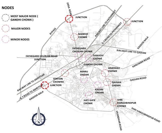
3.2. The city's image - Batala city
The path is most likely the most important organising element in image building. The main streets of Batala are seen in the figure below. The main road outside the walled city is G.T Road, which runs from Amritsar to Pathankot. G.T Road is home to several major government institutions. G.T Road also serves as the main node for Gandhi Chowk. G.T Road also has a bus stop and a railway station. The Jalandhar Road and Dera Road are the next major routes. Jalandhar Road Is a Major Road That Also Serves as a Major Route During "Babe Da Vivah" Because Nagar Kirtan Travels to Batala from Sultanpur Lodhi via Jalandhar Road as per Batala Master Plan (2010-2031).
4. Walled city of Batala
The walled city is located on the city's southern and eastern outskirts. It is not in the city centre. The smallest plot frontage in the walled city is roughly 1.5m, and the smallest plot frontage outside the walled city is 3m. The ground coverage is homogeneous (almost 100%) in the walled city since they are built extremely close to each other; the ground coverage outside the walled city is approximately 66%. Several houses have shared walls and range in height from 2 to 4 floors. Built form of historical significance has degraded or been altered through time. The walled city is the most densely populated area of the city and is most likely the city's oldest part. The walled city is located on the city's highest terrain.
4.1. Built open space
In terms of built mass analysis, the most dense area is the city's core, which is the walled city; the walled city has very few open spaces. When we leave the walled city, we see more open space and less density. The open spaces in Walled City include the front and back offsets of institutes, residential areas, colony parks, and courtyard typology houses. There are few open spaces in Walled City. In open mass analysis, narrow passageways twist and turn, eventually opening out onto a large space such as a public square or formal commercial street.
4.2. The path and nodes analysis
The route is most likely the most important organising element in image creation. The main commercial streets of the walled city include nehru street, chakri bazzar, bara bazzar, and tibba bazar.
Figure 2
|
Figure 2 Major
and Minor Nodes Source Author |
4.3. The district analysis
Figure 3

|
Figure 3 Map of District Analysis Source Author |
According to Lynch, the city is split into quarters or districts, each with its own distinct qualities. A quarter, often known as a district, is a medium to large sector of a city. According to Lynch's classification, the walled city of Batala can be separated into four distinct segments by the major commercial thoroughfare. The large Nehru thoroughfare, Chakri Street, Tibba Street, and Bara Bazar are all located on one large commercial thoroughfare that separates the walled city into two sections. The circular road outside the walled city divides the walled city with the remainder of the city. Choraha Chowk, Achli Street, and Ohri Street are three other prominent streets that separate the walled city into four halves.
4.4. The Landmark analysis
Kandh Sahib Gurdwara and Dera Sahib Gurdwara are the most important landmarks in walled Batala City. These two Sikh religious monuments are where Sikhs' First Guru Nanak Dev Ji wedded. The second building is Jami Masjid, which belongs to the Muslim community. Third, there are three major nodes that serve as landmarks: Nehru Gate, Khajuri Gate, and Achli Gate.
5. Issues confronting the city
5.1. Constructed form
· Stagnation of built form over time- the area comes under ASI (Archaeological Survey of India) with restrictive laws that have been in place for 20 years, leading the building form and its surroundings to freeze and deteriorate.
· Lost heritage value There are four architectural marvels or magnets in the area of high worth; these structures were built to create a character of the land area are currently working as separate identities.
· Disconnect between districts- There are entertainment, commercial, and institutional districts that operate independently and do not have connective elements such as open spaces or gardens for the inner-city or hub of Batala city.
· Movement Limited connectivity of bus routes or public transit to other sections of the city favours private ownership of vehicles in the area.
· All kinds of transportation are permitted, resulting in chaotic movement of automobiles and pedestrians, making the area always busy.
· Lack of parking for visitors and residents of the area, resulting in on-street parking and jam-packed roadways. 50% of the road cover is used for parking.
5.2. The city lacks a sociocultural component.
According to UDPFI Guidelines, (1996), standards, 69 Community Rooms would be required by 2031. There is currently no such institution in the city. There is one Community Hall and one library in the city. By 2031, 23 such halls would be needed. A recreational club is required for every 1 lakh individuals, which means that three such clubs would be required by 2031. Each 1 lakh people require a Music, Dance, and Drama Centre, which means three such centres are required. The region has tourism potential, but it is currently just a blank lot with a lovely statue in the middle.
5.3. Lack of urban personality
There is no land use, height, or density control, which disrupts the area's character contrasting architectural forms. There is a disconnect between the monuments.
Figure 4

|
Figure 4 Urban Landmarks of Batala City Source Author |
5.4. Scarcity of green spaces
There are no green zones along the road to reduce pollution. Green spaces account for 1.78% of the total area, compared to the standard minimum of 10% necessary.
6. Conclusion and Proposals
6.1. Ways to Reduce Congestion
· Connect to the cultural district by providing mini-e-buses that connect the walled city and the historic Jal mahal.
· By encouraging the use of public transport
· Pedestrian-friendly environment defined nodes
· Improve and strengthen mobility networks by establishing specific routes for goods-carrying vehicles.
· The location's accessibility via public transportation. Bringing greater room for public realm and parking is the strategy.
6.2. Kasur Nala Rejuvenation
Kasoor Nallah comes into Batala LPA from the northeast (Khokhar village) and leaves from the south (Chhit village). Along the route, it goes through a number of more settlements. The city also contains a large portion of the nallah. Untreated sewage, industrial effluents, solid waste, and ash from destroyed structures fill the nallah. The pollution level of the nallah is really high. The nallah's residential areas are infested. The entire length of the waterway.
As per Bindu et al. (1984). Enhancement of a natural drain transporting municipal refuse and storm water through rocky strata, directing dry-weather flow through a restricted channel. Provide a land development strategy along the Nallah. In order to enhance the natural environment, the proposed development should include two parcels of land larger than 25,000 square metres each for landscaping.
6.3. Site and its environments
· When we look at the site's land use plan and its surrounds, we can see that Jal Mahal is surrounded by 71% of residential area, significant educational institutes such as Baring College, schools, and one large civil hospital of Batala city civil hospital.
· One of the best colony urban estates recognised by PUDA in Batala is also close to a key heritage landmark.
· Furthermore, the walled city is the most densely populated, well-known, and visited location in Batala.
· As a result, it is critical to create such a location for city residents and tourists alike.
Figure 5

|
Figure 5 Cityscape
and its Surroundings Source Author |
People can come and socialise, and because it is a major hub of the city, it is necessary to revitalise the area of Jal Mahal, Hazira park so that it is beneficial to the residents of Batala city, students who come to nearby places for education, and moreover the area of Jal Mahal has very strong historical significance and is currently in poor condition. As a result, in order to make the city more liveable, one cultural area must be established.
6.4. Major and Minor Highways
6.4.1. Important Nodes
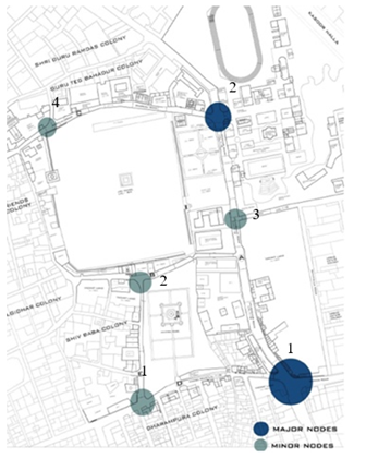
1) Anarkali Chowk is the most important node on the site, connecting people from Jalandhar Road to Anarkali Road. This is also the primary intersection where the Baring College entrance Gate is located.
2) The following major node on the site is Qadian Chowk, which serves as a major traffic interchange point. This node assists the user in approaching three major roads: Hazira Road, Jalandhar Road, and Qadian Road.
6.4.2. Nodes Minors
Node 1 connects the main road to the collector road, which goes to Urban Estate, one of the best colonies in Batala city.
Node 2 This is a minor node that connects to local roads such as the hospital road.
Node 3 This is the node that must be maintained because it is constantly clogged with traffic due to the hospital on the local road.
Node 4 This is the site's minor node, connecting to Gurdwara Guru Teg Bahadur Ji, Cattle Fair Ground, and Guru Ramdas Colony.
Figure 7
|
Figure 6 Major and
Minor Node Source Author |
6.5. Analysis of the Cutting Edge
The edge is the third important structuring element for the town's perceptual appearance. Edges are two-dimensional elements where the pathway function is less important than the boundary function. The most visible. The institutional edge, the main pathways, and the street façade provide the dual function of path and dividing edge between nearby city quarters in the site area. The map below depicts the location of key edges in Batala. When one enters the site, he sees a 10' long institutional boundary along a 300m long road. Another feature of the site area includes heritage buildings, which are surrounded by open terrain. The site area also includes a leisure space as an edge.
Figure 7

|
Figure 7 Edge
Analysis Source Author |
6.6. Landmark Evaluation
Landmarks are points of reference that can be seen from a distance. They are three-dimensional sculptures in the form of objects that can be entered and experienced from within.
· The most significant landmark in the site area is the Jal Mahal, which dates back to the Sikh period.
· The second stop is Shamsher Khan Tomb, which belongs to the Muslim community.
· Third, there is the Maharaj Sher Singh palace, which dates back to the Sikh era.
· The fourth is the Baring Chapel, which is built in the colonial style.
· The site contained various religious structures that also serve as prominent landmarks, such as the Gurdwara Shri Guru Teg Bahadur Ji.
· There are two temples and one ashram with a mandir.
· There is also one non-profit hospital on the property.
6.7. District Evaluation
According to Lynch, the city is split into quarters or districts, each with its own distinct qualities. According to Lynch's classification, a quarter or district is a medium to large section of a city. The site area can be viewed as divided by Jalandhar Road, Hazira Road, Anarkali Road, and Hospital Road, dividing the site into seven distinct parts; connecting these seven districts are roads such as Jalandhar Road, Anarkali Road, Hazira Park, and so on.
6.8. Area Level Proposed Structure Plan
1) Jal Mahal: Revitalising and redeveloping the region as a cultural district for the city, inhabitants, and visitors. This can be utilised at a "babe da vivah" or other function or meeting. Multiple users can enjoy the public realm along The Jal Mahal.
2) Water Body: to restore the traditional form and provide the as the name implies, the monument's principal feature is "water."
3) Open Museum: proposing two open museums, one on Punjabi culture and the other about the history of Batala.
4) Art Gallery, Library, and O.A.T.: To propose one art gallery, public library, and O.A.T. at Shubash Park near the cultural area so that citizens can use the library because Batala does not have one, and art gallery to highlight the brilliant work done by students and Batala city residents. One O.A.T. for open-air stage productions and theatre meetups.
5) Commercial Area: To suggest one food court where people may be served traditional meals and shops where traditional clothing and products can be offered.
6) Sports facilities: Because the area is surrounded by residential areas and institutes, one major sports area where residents may come and play games to stay fit is required.
7) Cultural Street: To propose one cultural street between the cultural district and Hazira Park that will solely depict Punjabi culture and allow people to learn traditional skills like as phulkari making, charkha, pottery, meals served on chulla, and so on.
8) Hazira Park: Creating a space for the city where diverse activities can be done, festivals can be performed, and a vast garden for cleansing the atmosphere.
9) Street Vendor Zone: When we travel on Jalandhar Road, the borders of the road are occupied by various types of vendors, which congest the region, hence this zone is recommended to transfer sellers away from Jalandhar Road.
CONFLICT OF INTERESTS
None.
ACKNOWLEDGMENTS
None.
REFERENCES
Batala Master Plan (2010-2031). PUDA (Punjab Urban Development Authorities), 199.
Bindu, N., Lohani, & Bindu, N. (1984). Environmental ManagementSouth Asian Publishers.
De Chiara, J., & Koppelman, L. (1975). Urban Planning and Design Criteria (2d ed.). VanNostrand Reinhold.
Divya. (2004). Built Heritage of Walled City, Duxbury Press, A Division of Words Worth Publishing Company, Balmont, California.
Lynch, K. A. (1960). The City's Image: Cambridge S.K. Kulshreshtha, "Dictionary of Urban and Regional Planning", Kalpaz Publication, 2006.
Muttalib, M. A., & Khan, A.A (1986). “Public Housing”, Sterling Publishers Private Limited” Naciye Doratli, Sebnem Onal Hoskara, Mukaddes Fasli. (2004). An analytical methodology for revitalization Strategies in Historic Urban Quarters: A Case Study of the Walled City of Nicosia North Cyprus: Turkey
Nicoll, R. (1964). Book Review: New Towns for Old : The Technique of Urban Renewal by Wilfred Burns, Leonard Hill, 1963, 230, 42/-. Urban Studies: An International Journal of Research in Urban Studies, 1(2), 205-206. https://doi.org/10.1080/00420986420080351.
UDPFI Guidelines, (1996). Centre for Research, Documentation and Training, Institute of Town Planners, India.
Whittick, A. (1974). “Encyclopaedia of Urban Planning”. McGraw- Hill Book Company.
|
|
 This work is licensed under a: Creative Commons Attribution 4.0 International License
© ShodhKosh 2023. All Rights Reserved.